Boundary Waters Canoe Area
 
         
BWCA Photo
 
Map of Entry Points, PMA's and Map Overlays of the Boundary Waters Canoe Area Wilderness (BWCAW)
Map of the BWCA

BWCA Entry Points

1-Trout Lake

16-Moose/Portage R. N.

26-Wood Lake

34-Island River

42-Brule Lake ONLY

51-Missing Link Lk.

62-Clearwater Lake 75-Little Isabella R.

4-Crab Lake

19-Stuart River

27-Snowbank Lake

35-Isabella Lake

43-Bower Trout Lake

52-Brant Lake

64-East Bearskin Lk.

77-So. Hegman Lake

6-Slim Lake

20-Angleworm Lake

28-Snowbank (restr.)

36-Hog Creek

44-Ram Lake

54-Seagull Lake

66-Crocodile River

78-Brule Lake Trail

7-Big Lake

21-Angleworm Lk Tr.

29-No. Kawishiwi R.

37-Kawishiwi Lake

45-Morgan Lake

55-Saganaga Lake

67-Bog Lake

79-Eagle Mtn. Trail

8-Moose River S.

22-Mudro L. (restricted)

30-Lake One

38-Sawbill Lake

47-Lizz/Swamp L.

57-Magnetic Lake

68-Pine Lake

80-Larch Creek

9-Little Indian Sioux S.

23-Mudro Lake

31-Farm Lake

39-Baker Lake

48-Meeds Lake

58-South Lake

69-John Lake

82-Border Rt (Center)

12-Little Vermillion L.

24-Fall Lake

32-S. Kawishiwi R.

40-Homer Lake

49-Skipper/Portage

60-Duncan Lake

70-N. Fowl Lake

84-Snake River

14-Little Indian Sioux N.

25-Moose Lake

33-Little Gabbro L.

41-Brule Lake

50-Cross Bay Lake

61-Daniels Lake

74-Snowbank Trail

86-Powwow Trail

Overlay Maps (shown on map above) of the BWCA (showing approx. area of each numbered McKenzie(TM) Maps)

Map #1-Pine Lake

Map #4-Gunflint Lake

Map #7-Tuscarora L.

Map #10-Basswood

Map #13-LacLaCroix

Map #16-Burntside L

Map #19-Isabella Lake

Map #2-Clearwater Lake

Map #5-Granite R. Rt.

Map #8-Knife / Kek L

Map #11-Jackfish L.

Map #14-Loon Lake

Map #17-Fall Lake

Map #20-Alton

Map #3-Ball Club

Map #6-Saganaga Lake

Map #9-Snowbank L.

Map #12-Moose R.

Map #15-Trout Lake

Map #18-Lake One

Map #21-Sawbill Lake

BOUNDARY WATERS CANOE AREA (BWCA) - Scroll down to learn more about this website


About this Website:

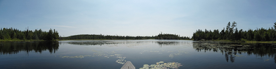
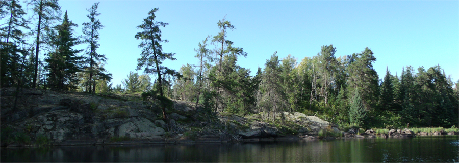
The main purpose of this website is to provide firsthand virtual visits to the BWCA. This allows you to see a place you may have visited before in the BWCA or help you plan a new trip to the Boundary Waters. Your viewpoint will be as if you are actually out there.  You will see and hear from a first person perspective what you would encounter if you were canoeing, portaging or camping in the Boundary Waters Canoe Area.

Reflection Lake - Spider Lake Primitive Management Area BWCA
Reflection Lake - Spider Lake Primitive Management Area


As time goes on, more and more lakes, rivers, creeks, entry points, portages, pictographs and campsites will be added to the website.  This allows you to actually do a virtual trip through the Boundary Waters Canoe Area starting from an entry point or the lake or stream of your choosing.  The maps and links of the website are placed in such a way as to allow you to click through to the next most likely destination along your chosen route, or even change your route midway through your trip.  If you get cabin fever for the BWCA in the middle of winter, this is a way to cure it (at least a little).  Also, you can use this information (photos, videos, descriptions) to remind yourself of an old trip or plan for an upcoming trip (you’ll know what to expect).  This could be particularly useful if you are a first timer to the BWCA.  If you’ve ever sat around your campsite pouring over your BWCA maps, and just wondered what that really remote lake might be like, this website may be able to show you. If you are going to the BWCA with some tenderfoots, this website may be able to help you determine if a portages are difficult; you'll be able to virtually walk it and decide for yourself.


Much of the orginal groundwork for this website is built around the BWCA's Primitive Management Areas (PMA’s), but with the overall goal of eventually showing the entire Boundary Waters (and Quetico Provincial Park too).  PMA's are remote, unmanaged regions of the BWCA designated by the U.S. Forest Service. There are 12 PMA's in the BWCA and they encompass about 1/8th of the entire BWCAW. Many of these PMA areas are seldom seen, even by regular visitors to the BWCA. (Visit this page to find out about PMA's - What are PMA's?)


The BWCAwild.com website also is a resource for statistical information.  The website includes information on such things as historical fires, PMA lake depths, water clarity, fish, lake sizes (acres) and creek and river lengths.  Videos and statistical lists will be continually updated and added over time.

Plukesley Lake in the BWCA Weasel Lake PMA
Plukesley Lake - Weasel Lake Primitive Management Area


Thanks for visiting. Enjoy your trip!


PMA #1: Weeny Lake

PMA #3: Sundial Lake

PMA #5: Spider Lake

PMA #7: Pitfall Lake

PMA #9: Humpback Lake

PMA #11: Weasel Lake

PMA #2: Canthook Lake

PMA #4: Tick Lake

PMA #6: Drag Lake

PMA #8: Mugwump Lake

PMA #10: Hairy Lake

PMA #12: Fungus Lake

- www.BWCAwild.com - All Rights Reserved.
All images, videos and text property of www.BWCAwild.com - No reuse without permission.
DISCLAIMER AND TERMS OF USE --- CONTACT US --- PRIVACY POLICY