Isabella Lake/Lake Insula Area
Overlay #19 in the BWCA
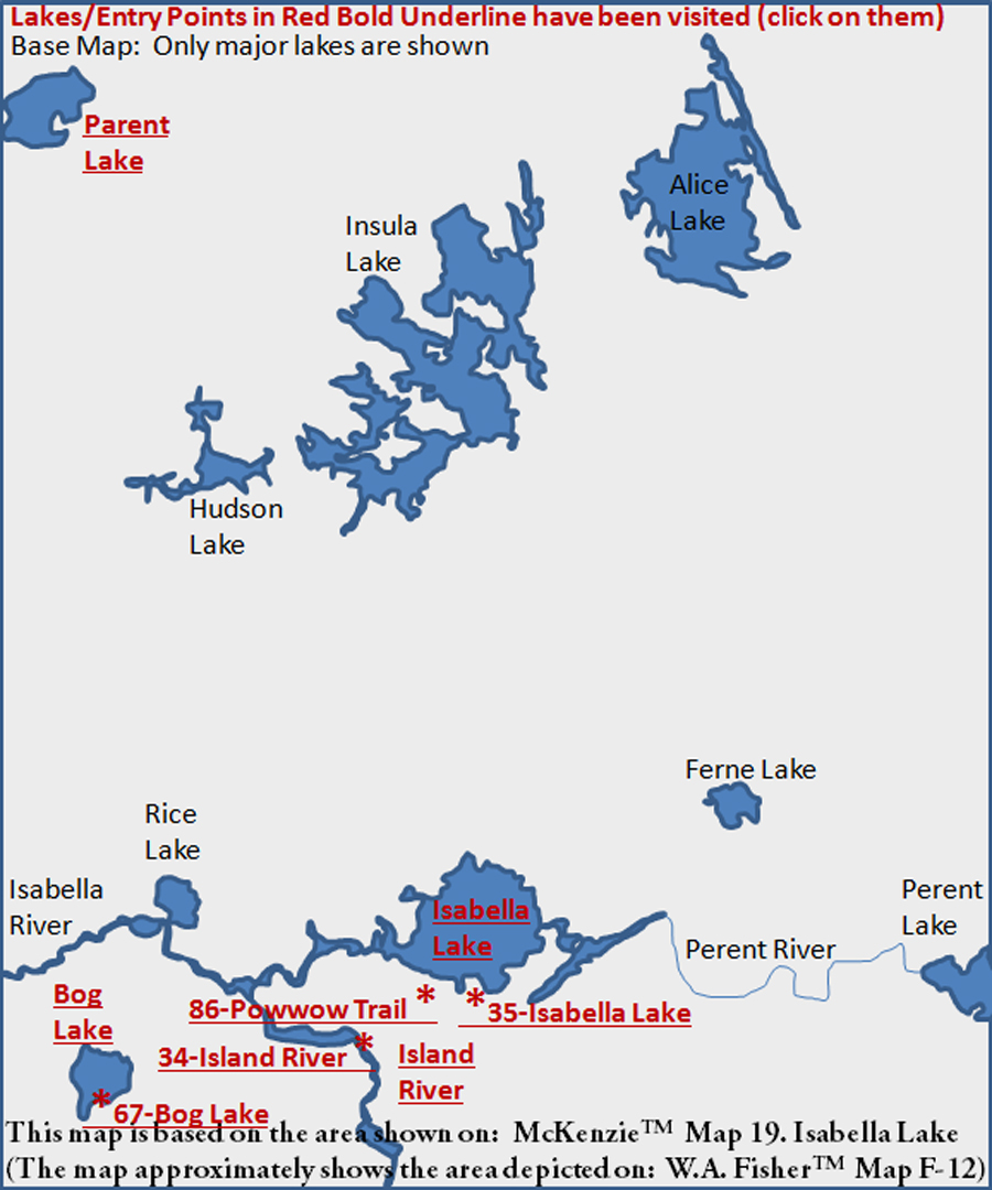
A single road leads out to BWCA Entry Point 34, BWCA Entry Point 35 and BWCA Entry Point 86. All three of these entry points are well within the Pagami Creek Fire zone. There are large stands of trees remaining in this area; it is just burned forest for as far as you can see. The Island River entry point is next to the bridge crossing. Less than one mile further down the road is the combined Isabella Lake/Powwow Trail entry point parking area. The Powwow Trail was severely damaged by the 2011 forest fire and is not recommended at this time.
Isabella Lake is a large bowl of a lake completely surrounded by charred forest. Isabella Lake provides access to the Perent River route and the Isabella River route. There used to be a route up to the Ferne Lake area, but this is probably no longer the case since the fire. That area is within the Fungus Lake Primitive Management Area (PMA) and thus is no longer a maintained route by the U.S. Forest Service. You are allowed to camp in PMA's, but you must have a separate permit.
The Island River, if you go under the bridge from the entry point, leads to the Isabella River. If you go the other way (upstream), you head out of the BWCA, but you also can see a very good pictograph site. These pictographs are about four miles upstream. See the Island River page on this website for more information (links below).
Bog Lake is a stand alone lake with no other routes connected to it. So if you use BWCA Entry Point 67, you are going to Bog Lake and that's that. Note that the portage out to Bog Lake is a real bear.
Other large lakes in this area are Lake Insula and Perent Lake. Lake Insula is most easily accessed from the far west at Lake One (BWCA Entry Point 30). Lake Insula is at the north edge of the 2011 Pagami Creek Fire zone. Lake Insula is also on the north side of the Fungus Lake PMA.
Perent Lake is connected to Isabella Lake by the Perent River. The Perent River is a rugged route, particularly in low water periods. Perent Lake can also be accessed from the east from BWCA Entry Point 36 - Hog Creek. The Hog Creek entry point is along the same road as BWCA Entry Point 37 - Kawishiwi Lake.
The following major lakes (and many other minor lakes) are shown on the McKenzie(TM) #19 (Isabella Lake) Map:
Alice Lake
Bog Lake
Ferne Lake
Hudson Lake
Insula Lake
Isabella Lake
Isabella River
Island River
Parent Lake
Perent Lake
Perent River
|