Fungus Lake Primitive Management Area
This PMA is most accessible from Lake Insula, Kawishiwi Lake and Lake Isabella. Of the 31 lakes in this PMA (counting North Hope Lake), only five were unaffected by the 2011 Pagami Creek Fire. These are Assawan Lake, Chickadee Lake, Fungus Lake, Puffer Lake and Record Lake. The fire burned almost the entire primitive management area so it will be quite desolate in appearance to visitors. Because of the fire, many old trails that are helpful in bushwhacking will probably have disappeared. The creeks flowing through a burned area often have lots of fallen trees in them so they can be more difficult to navigate; particularly the really small creeks which do not have enough flow during floods to dislodge and remove dead trees from their channels.
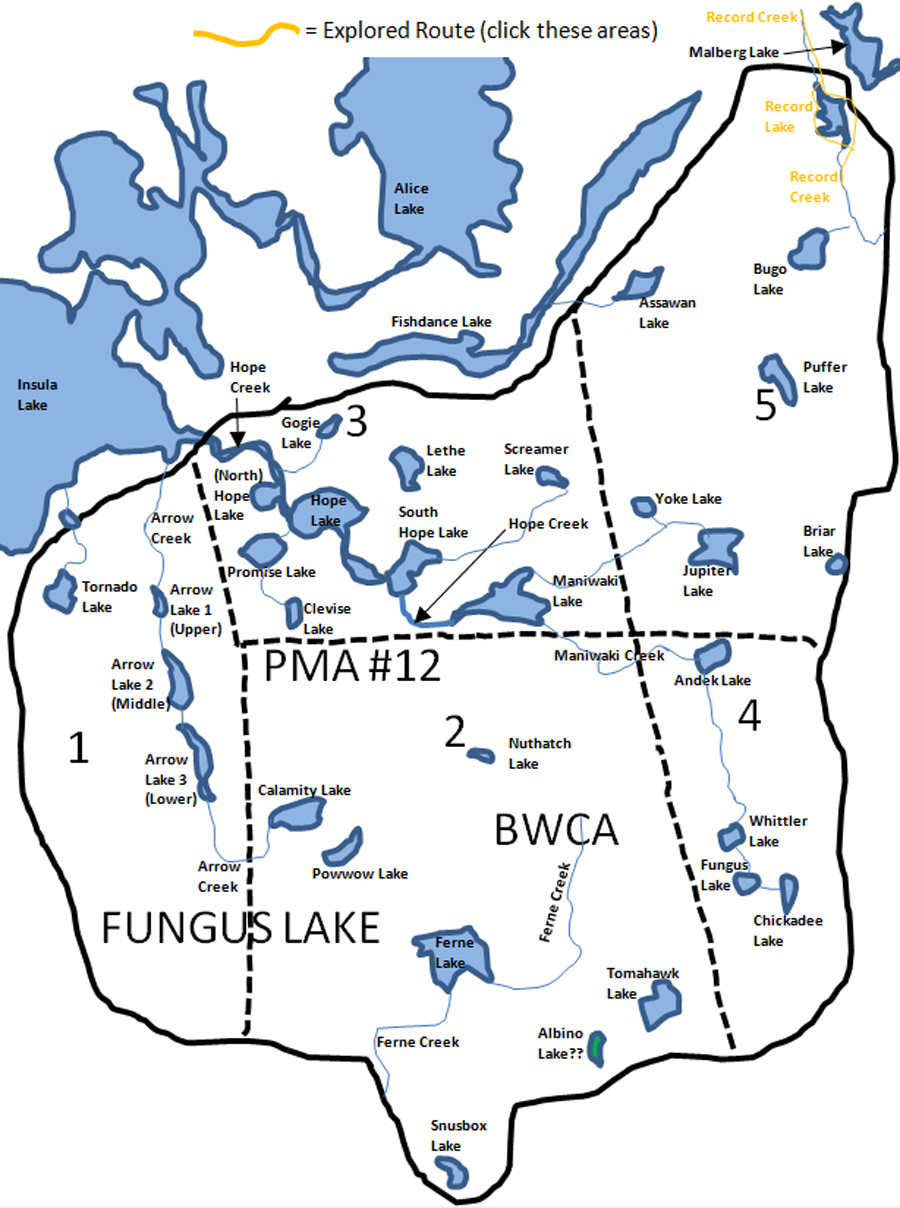
North Hope Lake is the large often unnamed lake downstream of Hope Lake along Hope Creek. So, it lies northwest of Hope Lake in the direction of Lake Insula. This is a good sized lake and has plenty of water and it is easy to refer to it as North Hope Lake rather than "that unnamed lake northwest of Hope Lake along Hope Creek". See what I mean?
Likely the easiest place to explore in this PMA are the lakes connected to Lake Insula by Hope Creek. Hope Creek is fairly wide and will contain relatively few obstructions. The usual beaver dams and an occasional downed tree will likely impede progress though. Maniwaki Lake, past South Hope Lake, is a large PMA lake that is worth a look. Hope Creek between Maniwaki Lake and South Hope Lake appears to require several bushwhacks from satellite imagery before you reach Maniwaki Lake itself.
Old maps and several posts on popular BWCA forums show/mention a long portage that used to lead into Ferne Lake. There also used to be a portage from Baskatong Lake on the east side of this PMA into Andek Lake. This old portage is listed at 322 rods. This route shows up on 1967 Fisher maps and other maps around that time. Heading north, old maps show a route from Maniwaki Lake to Screamer Lake of 140 rods and then from Screamer Lake up to Fishdance Lake that required another 320 rod portage.
Regarding the three Arrow Lakes. The Minnesota Department of Natural Resources discusses these bodies of water as if they were three separate lakes, so that is how I am displaying them in this website. They are referred to, depending on the literature, as Upper Arrow Lake, Middle Arrow Lake and Lower Arrow Lake. They are also called from north to south: Arrow Lake 1, Arrow Lake 2 and Arrow Lake 3. They are even referred to singularly as just Arrow Lake.
There is one real oddball lake, or is it a peat bog, or does it not exist as a lake at all? This weird lake is Albino Lake. It appears as water on old Fisher Maps, but it does not have a name. On Google Maps, satellite images show it as a peat bog with no water. It also shows up on McKenzie #19 - Isabella Lake as a bog. It is named Albino Lakes on Google Maps and on the McKenzie map. The older USGS topo maps also name it Albino Lake. Albino Lake seems a good name, as it is the same color as the forest that surrounds it; green.
History of the East Loop of the Pow Wow Trail
The Pow Wow Trail starts at the site of the former location of the town of Forest Center. Forest Center arose as a logging camp that supported the Tomahawk Timber Company. The company was likely named after Tomahawk Lake. The town of Forest Center had a maximum population of about 250 people at the height of logging operations. The town included about 50 homes, a school, a general store and other support buildings for logging operation. The town only existed from 1949 to 1964. The existing buildings were either removed or demolished in 1965. Many of the residents moved to the present town of Isabella, Minnesota.
Extending out from the town of Forest Center during the period that the Tomahawk Timber Company was active, was a network of logging roads. These logging roads, after they were abandoned in 1964, were eventually developed by the Youth Conservation Corp into the Pow Wow Trail. The Pow Wow Trail encompassed two large loops; a west loop and an east loop. Eventually, in the early 1980's, the eastern loop of the Pow Wow Trail was abandoned and improvements were focused on better development of the more scenic western loop. Currently is is only the western loop of the Pow Wow Trail that is hiked in the BWCA. It is the abandoned eastern loop of the Pow Wow Trail that used to pass through what is now the Fungus Lake Primitive Management Area. This loop extended from Forest Center, past Powwow Lake, then out to Nuthatch Lake toward the east. The old east loop then continued over to the west shorelines of Chickadee and Whittler Lake. Finally the trail went southwest down past the southeast side of Tomahawk Lake and eventually down to the Perent River area and returning to Forest Center. At the time of the 2011 Pagami Creek Fire, this eastern loop of the Pow Wow trail would have been in an unmaintained state for at least 25 years. It probably received decreasing use through the 1980's and 1990's as it deteriorated. The trail is shown on the U.S. Topographic maps. The trail is also shown and highlighted on this websites maps. The 2011 Pagami Creek Fire probably destroyed most of what remained of this east loop of the Pow Wow Trail. There is one section of the trail that did escape the fire and that is the part along the west shores of Chickadee and Whittler Lake and the area down to the southeast of Tomahawk Lake and Albino Lake. So some vestige of the trail may still exist out there.
|