What to Expect in a Primitive Management Area
Do you like backpacking? Do you like canoeing? If you like both, combine the two activities and that pretty much sums up the experience of visiting the PMA's in the BWCA; except the hiking trail is non-existent and the waterways are clogged with beaver dams and marsh grass too thick to paddle through much of the time. Then there is the thigh deep mud...
Not all PMA's are created equal. Some are easier than others and have lakes that aren't too hard to get to; the bushwhacks are easier or the lakes are somewhat grouped together. Some PMA lakes are very difficult to reach and likely have not been visited for a decade or more. Many of these lakes used to have maintained portages and campsites, but the U.S. Forest Services stopped managing them and is allowing them to return to their natural state. Therefore, reaching these places will likely get more difficult as the old portage trails slowly fill in; many are almost invisible or completely gone already.
The 12 PMA's in the Boundary Waters Canoe Area
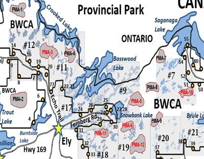
The dozen PMAs in the BWCA cover an area of 124,000 acres. The entire BWCA is 1,090,000 acres, so PMAs make up just over 11% of the entire Boundary Waters. There are just over 170 lakes in the 12 combined PMA's. Here is a map showing the relative locations of all twelve:
List of the Primitive Management Area:
Being Safe in a Primitive Management Area
It is quite easy to get turned around when bushwhacking through the forest. The forest oftentimes appears the same in all direction. Since PMA's do not have portage trails (or only faint remains of old portages that used to go through them), make sure you carry a compass (and a GPS if possible) along with applicable maps of the area. In addition, make sure you know how to use these tools. Try to follow landmarks and keep tabs on your surroundings. Creeks and shorelines are particularly good of course. Creeks often connect the lakes through PMA's, but not always. Be careful with your gear. It is easy to set your gear down and then come back to where you think you left it and find it isn't there. Your gear is probably in the same place, you probably are not. It is hard to see a pile of gear even 25 feet away in dense forest. Also be careful that you don't injure yourself. There are few people in these areas so help is a long way off. Less than 400 reservations per year are made for all the BWCA PMA's combined! Like any BWCA trip, leave an itinerary with someone so they know when you are expected back from your trip. I have never encountered another party while in these areas.
PMA Permits and Other Rules
A Primitive Management Area (PMA) is an unmanaged region of the Boundary Water’s Canoe Area Wilderness (BWCAW). While the BWCAW is a relatively remote wilderness area, there are still plenty of people to be found; particularly within a portage or two of an entry point. To mitigate the roughly quarter million visitors that the BWCAW sees each year within its 1.1 million acres, the U.S. Forest Service has a permit system limiting the number of visitors that can enter through each of the roughly 50 designated entry points around the periphery of the park. Camping in a PMA requires a secondary permit and there are additional RULES AND REGULATIONS.
The U.S. Forest Service restricts camping in PMA’s by requiring a second rider permit along with your regular BWCAW permit. You request this PMA permit when you go to pick up your regular BWCA permit. You can call ahead to ensure the PMA permit for your desired region and zone is available, but they almost always are. Only one group per week is allowed into a PMA regions zone. The maximum suggested group size is six people, but you can have a group size up the the maximum allowed in the BWCA. You are allowed to camp anywhere, but leave-no-trace camping is highly encouraged. Try to camp on areas of bare rock and keep campfires to a minimum. Keep the area of your campsite small. Typically the U.S. Forest Service only issues about 100 of these PMA permits per year for all of the 12 PMA’s combined. So given that the PMA’s encompass roughly 1/8th the entire area of the BWCAW, they see only about 400 people per year versus 250,000 for the rest of the wilderness park. If you have a BWCA day permit, you can travel through a PMA, but you cannot camp in the PMA as it is part of the BWCA.
Traveling through a PMA: What to Expect
While there are no roads or motorized modes of transportation allowed in the BWCAW (except a few larger lakes on the edge of the wilderness), there are enough canoeists to make getting the better campsites a bit of a musical chairs act if you wait until too late in the day to find one. To travel between the lakes in the BWCAW, a system of portage trails, many dating back to the time of the voyageur fur traders are used. There is often a fair amount of traffic on these portages since they form sort of a bottleneck between the busiest lakes on the most heavily traveled routes. These portages are maintained by the U.S. Forest Service so that the wilderness doesn’t slowly reclaim them.
A PMA differs from the regular areas of the BWCAW in several key aspects. There are no portage trails. Travel between lakes is by bushwhacking; you make your own portage trail. You will want to be experienced in backcountry travel before proceeding into the PMA's. Carry some survival equipment. Make sure you have a map, GPS and/or compass and know how to use them. It is extremely easy to get turned around and lose your sense of direction in dense forest.
In some cases, remnants of old portages can be found, but don’t count on it. Another difference is that there are no designated campsites. You can camp where you like as long as it conforms to PMA regulations. You are not likely to encounter any other humans while visiting a PMA. Each of the 12 PMA’s are broken into several zones (typically two to six zones per PMA). If you look at a BWCAW map that is typically used for navigation, the PMA’s are typically located in the voids between the larger lakes and the red portage lines drawn on the map. All PMA lakes are small to medium in size, and many are swampy. Some PMA lakes support good fisheries, but many do not even though they may look "fishy".
Happy bushwhacking and be safe!
P.S. Here is the brochure handed out by the U.S. Forest Service that explains Primitive Management Areas and displays their official boundaries:CLICK HERE TO OPEN PDF (requires Adobe Reader).
|

