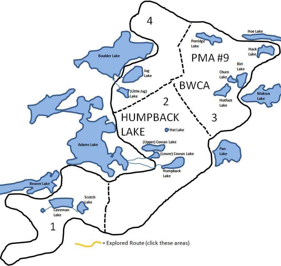
Humpback Lake Primitive Management Area
If you look at a satellite image of Humpback Lake on Google Maps, this lake has a couple of islands, and a few more sunken islands. It also appears to be very clear. Humpback Lake is down a marsh/creek valley from the complex eastern bays of Adams Lake. Just north of Humpback Lake lies its sister lake; Lake Cowan. Cowan Lakeis accessed from a good sized creek directly from Adams Lake. The tricky part about Cowan Lake is determining which of the two lakes is actually Cowan Lake. The northern lake usually appears larger on maps, however this lake is actually half the size it appears on these maps since its entire eastern half is now a peat bog with a creek running through it. Cowan Lake obviously used to fill the area where the peat bog is, but no longer. Hat Lake may also have lost its water because it drains into the low water Cowan Lake. The smaller lake to the south is often labeled on maps as Cowan Lake too. So visit both of the Cowan Lakes and you'll know you've been there! For the purposes of this website, I call them (Upper) Cowan Lake and (Lower) Cowan Lake just to make it clear.
Current satellite images show low water levels in (Upper) Cowan Lake and Hat Lake.
A short bushwhack through a marsh from the southeast shore of Boulder Lake gets you into the largest lake in the Humpback Lake PMA, that being Jug Lake. Jug Lake appears relatively shallow and a bit marshy so if you fill your jugs here, the water may be a bit chewy. Just south of Jug Lake is another good sized lake that is unnamed. For the purposes of this website, I have named it (Little) Jug Lake as this is easier than calling it "that unnamed lake"..
Two lakes that are more difficult to reach are Porridge Lake and Hack Lake along the northern edge of the Humpback PMA near the border with the Mugwump PMA. Hack requires a bushwhack straight through the forest probably best attempted from the long east/west running Maymay Lake. Hack Lake looks to be another clear lake in this PMA. Porridge Lake, over a half mile west of Hack Lake, resembles its name. It is a heavily vegetated lake that probably has the consistency of thick porridge. Porridge Lake represents a lake in its final stages before it becomes a marsh or peat bog. The approach to Porridge Lake is probably from its east down the small creek running out of the eastern-southern tip of Fee Lake.
Moving to the eastern side of the Humpback PMA, there is another nice little grouping of lakes to the west of Makwa Lake. These are: Birl Lake, Churn Lake and Hotfoot Lake. They are all relatively easy bushwhacks as you can use the stepping stone approach of Makwa Lake to Birl Lake to Churn Lake and finally to Hotfoot Lake.
In the south of the PMA, just to the southeast of Beaver Lake, one finds what could be considered the BWCA's “Man Cave”. A 50 rod bushwhack out of the eastern tip of Beaver Lake gets you into Caveman Lake. Caveman Lake is of course next to Scotch Lake. A caveman’s got to drink after all. The bushwhack to Caveman Lake from Beaver Lake is through what appears to be pure forest so it could be you could use a belt after getting out to this lake pairing.
|