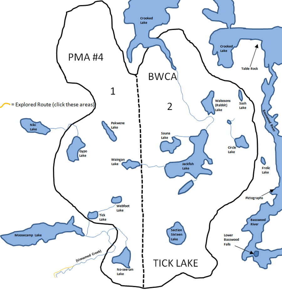
Tick Lake Primitive Management Area
A through route from Niki Lake to Crooked Lake will garner you six of the 12 named lakes in this primitive management area. Starting from Niki Lake, there used to be a portage to Gypo Lake of 53 rods or so. Out of the northeast corner of Gypo, a long 170 rod portage extended out to Pakwene Lake. Pakwene Lake used to have a campsite on its south end. Near this old campsite there used to exist another portage trail; again quite long, that goes to Maingan Lake. Finally, from Maingan Lake there is a creek that takes you east to the gem of this PMA, Jackfish Lake. A portage used to circumvent about the last half of this creek and was located on its south side. That portage was about 50 rods long. Jackfish Lake supports two campsites and is the largest of any lake within the 12 PMA's in the BWCA at 224 acres. From the northwest corner of Jackfish Lake is a stream that leads to Sauna Lake. There used to be a 50 rod portage connecting the closest points between these two lakes. As of 2002, there was no evidence of the old portage between Jackfish Lake and Sauna Lake or of the portage to Maingan Lake (Pauly, 2005). A party can complete the “shortcut” to Crooked Lake by continuing past Jackfish Lake into Wabosons Lake. Wabosons Lake, which was once called Rabbit Lake on some maps, is a short 20 rod portage north of Jackfish Lake. Wabosons is a derivative of the Ojibwe word for little rabbit, 'waboozoon'. Finally, a 120 rod unmaintained, but easily traceable portage, leads from Wabosons Lake into Sunday Bay on Crooked Lake. Note that just to the east of this portage is an interesting place to visit on Crooked Lake called Table Rock.
There is a small group of lakes just east of Moosecamp Lake along, as far as can be discerned, an unnamed river that connects Moosecamp Lake to Fourtowns Lake. This unnamed stream is often called "Moosecamp Creek". These lakes are No-see-um Lake, Webfoot Lake, and Tick Lake (the PMA’s namesake). No-see-um Lake is of fair size, but Webfoot Lake and Tick Lake appear to be shallow, swampy places to visit. Old maps of this area show a long portage through a swamp from Horse Lake to No-see-um Lake. As of 2002, no sign of this portage exists (Paul, 2005). Tick Lake probably barely meets the definition of a lake, but they needed a dastardly sort of name in which to give the PMA its name, so a lake it remains.
There are a two other lakes on the east edge of the Tick Lake PMA, namely Sash Lake and Circle Lake. These two lakes will require a serious bushwhack to reach from Crooked Lake. Section Sixteen Lake, to the south of Jackfish Lake, is a large circular lake on a dead end bushwhack that will see very few paddlers.
References:
Pauly, Daniel, Exploring the Boundary Waters (Minneapolis: University of Minnesota Press, 2005), 136, 157.
|