Fool Lake is fairly large (for a PMA lake) and is at least 14 feet in depth (maximum depth recorded using fish finder paddling throughout the lake). The lake has one reasonable campsite located in the eastern end of the lake on the south shore. This site appears to see few visitors, but had enough space for tent pads and also had a relatively nice canoe landing area. Fish finder detected fairly good fish activity and a number of fish were seen jumping and swirling in the lake.
The bushwhack into Fool Lake is somewhat difficult to find. To locate it, head up the creek from the unnamed lake between Fool Lake and Cross Bay Lake. This same creek also leads to Lucky Pay Lake. When you get to some large cliffs along the creek, you will notice a water passage going through the marsh grass when you are facing the opposite direction from these cliffs. This "beaver run" is perhaps a hundred feet long and leads to a cleared landing, which is obviously the start of an old portage trail. The portage trail while traceable, is really more of a bushwhack now. This bushwhack will have you alternating between carrying your canoe and paddling it. There is a nasty mud hole just below a beaver dam that holds back a small pond, about midway along the portage. The entire bushwhack into Fool Lake is through dense forest.
From Fool Lake, it is only a short additional bushwhack into Jester Lake. The bushwhack to Jester Lake follows a small unnavigable creek and is less than 20 rods. Jester Lake is worth a visit as it is deep and quite scenic. Jester Lake also has some interesting rock formations. A favorite lake among PMA lakes that I have visited. The creek coming into the bay in the middle of the south shore of Fool Lake is not canoeable. This creek flows out of Swollen Ankle Lake, which lies about 1/4 mile to the south of Fool Lake. It appears that the best approach to Swollen Ankle Lake would be through Yogi Lake which lies south of Swollen Ankle Lake. Another way to Swollen Ankle Lake would be to take the creek from Lucky Pay Lake. Much of this creek is quite floatable in a canoe.
Could it be that Fool Lake got its name for all the voyagers who ended up with sore ankles trying to bushwhack to Swollen Ankle Lake from Fool Lake?
A number of small fires affected the eastern part of the Boundary Waters Canoe Area Wilderness in 1936, including some areas in the Hairy Lake Primitive Management Area.
1894 saw a large number of fires throughout the entire BWCA. The fire in this area is called the Snipe Lake/Round Lake-Gunflint Lake/Pine Lake Area Complex. This fire probably got its start near Round Lake, a popular BWCA entry point.
A fire started within what is now the Hairy Lake Primitive Management Area. The ignition point for this blaze was probably somewhere between Mass Lake and Auk Lake. This fire, which took place in 1846, is called the Auk Lake/Long Island Lake/Cross Bay Lake Complex.
The 1824 Long Island Lake/Rush Lake/Loon Lake Complex probably burned the eastern part of the Hairy Lake Primitive Management Area and moved eastward. It likely started somewhere around Snipe Lake, or perhaps the northwest part of Long Island Lake.
Way back in 1727, the Gordon Lake/Brule Lake/Winchell Lake Complex burned this area too. It probably began somewhere near Sawbill Lake.
Click on the photos below to see the full resolution image - Use your browsers back button to close photo and return to this page.
The approach to Fool Lake actually begins way back at Cross Bay Lake. From Cross Bay Lake you must bushwhack uphill to a fairly good-sized unnamed lake. After paddling across the unnamed lake, follow a creek until you reach an area with a cliff face on your left. At this point you must choose to continue relatively straight and head for Lucky Pay Lake (at the end of the creek you are currently following), or turn right (directly opposite the cliff face) and follow a small "beaver run" to the location of the start of the bushwhack out to Fool Lake.
Note: Here is the web page for this "unnamed lake" if you want a bit more detail than shown here. You carry your canoe uphill from Cross Bay Lake, around a small waterfall, and eventually reach a scenic unnamed lake. There is a wall of rock next to the waterfall that requires climbing up the rock and then pulling your gear and canoe up. Paddling across the unnamed lake will bring you to the creek on its opposite shore that leads farther into the Hairy Lake PMA; namely to Fool Lake, Jester Lake and Lucky Pay Lake (the Gambler Lakes or Royal Court Lakes).
Paddling across the unnamed lake. This paddle begins at the Cross Bay Lake bushwhack which is found near the point where the creek flows out of the lake. On a direct line, paddle to the southeast to the mouth of the creek that drains both Fool Lake and Lucky Pay Lake.
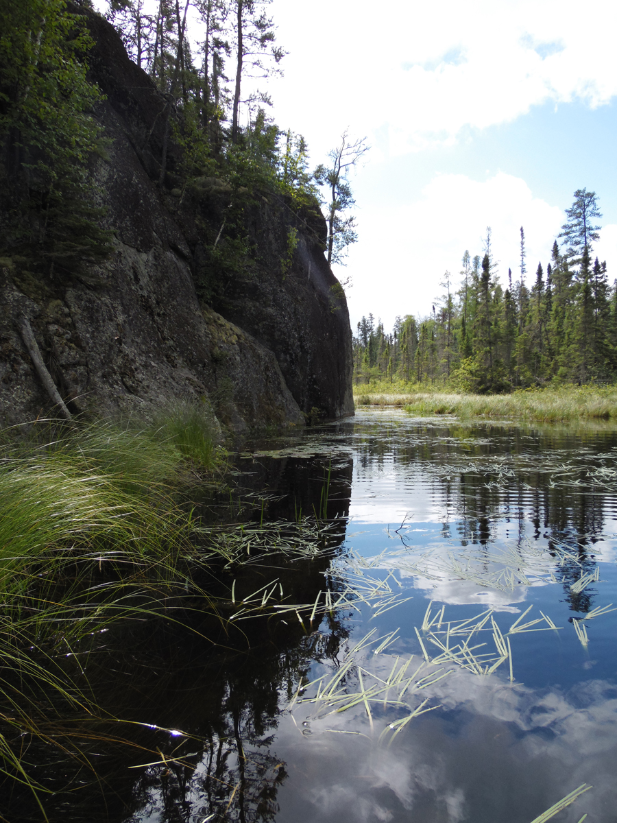
Upon reaching the south shore of the the unnamed lake, head upstream along a little creek. As you reach an area with high cliffs on the left, you notice that when looking away from the cliffs in the other direction, there is an open water passage that leads back toward the forest edge. This is the way to Fool Lake. If you continue along the creek past the water passage at the base of the cliff, it takes you to a small rapids where the bushwhack begins to Lucky Pay Lake.
Bushwhack to Fool Lake
As you paddle up the creek from the unnamed lake, look for this cliff formation. If you continue straight past this cliff along the creek, you will be on your way to Lucky Pay Lake. If you want to go to Fool Lake, turn right when directly in front of this cliff and you will see a channel of water going back into the swamp grass. Follow that little channel to the start of the bushwhack leading to Fool Lake.
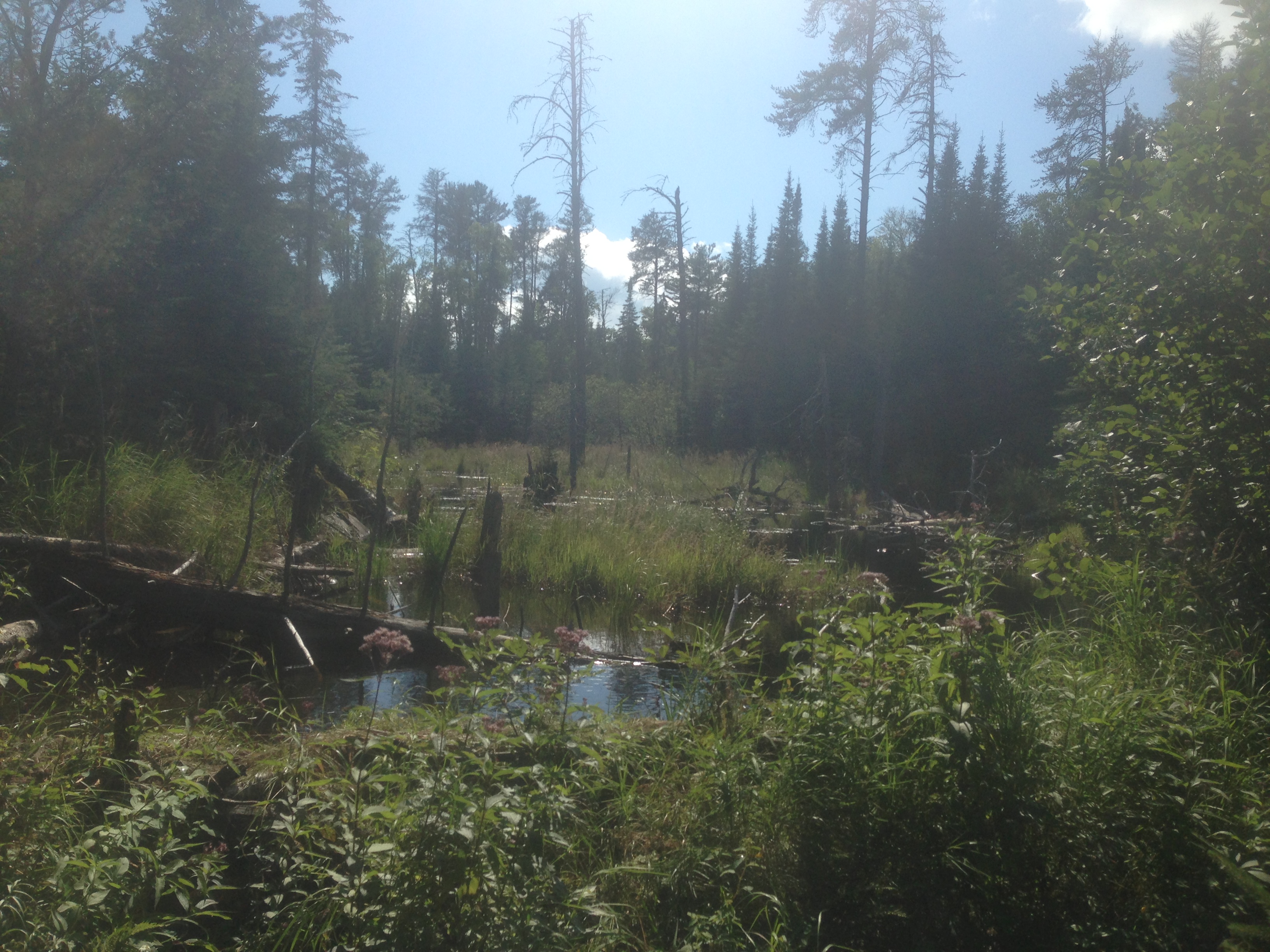
From the fairly large cliffs along the creek, south of the unnamed lake, you find and head up a channel going through the marsh grass, back toward the forest line. A short paddle up this channel and you spot a surprisingly good portage landing. Unload and start your bushwhack from here. As you approach a beaver dam, you discover an evil mudhole below it. The dam holds back a small pond, while only allowing a trickle of water through. This little pond is visible on your BWCA map. Unfortunately, while looking down at your map, you stepped into the mud. Do not step in the mud! After extricating yourself from the mud and lifting your canoe over the dam, you paddle across the pond. On the other side of the pond you start another bushwhack until you reach another navigable part of the creek. The creek has plenty of obstacles (i.e. logs, beaver dam). Eventually you come to the end of navigable water along the creek. A final bushwhack gets you to the north tip of Fool Lake. The lake might be named appropriately given the effort it took to get here.
This is the "Mud Hole" you extricated your leg from. The mud is deeper than your paddle is long (tested it). It was impossible without digging just to get a foot out of it, that was only in up to the ankle, so...take care not to step in this hole. This is actually equivalent to quicksand and you may be in trouble if you went in waist deep and had nobody along to help you out. This formed because the beaver dam allows a very slow trickle of water through that has super saturated this mud.
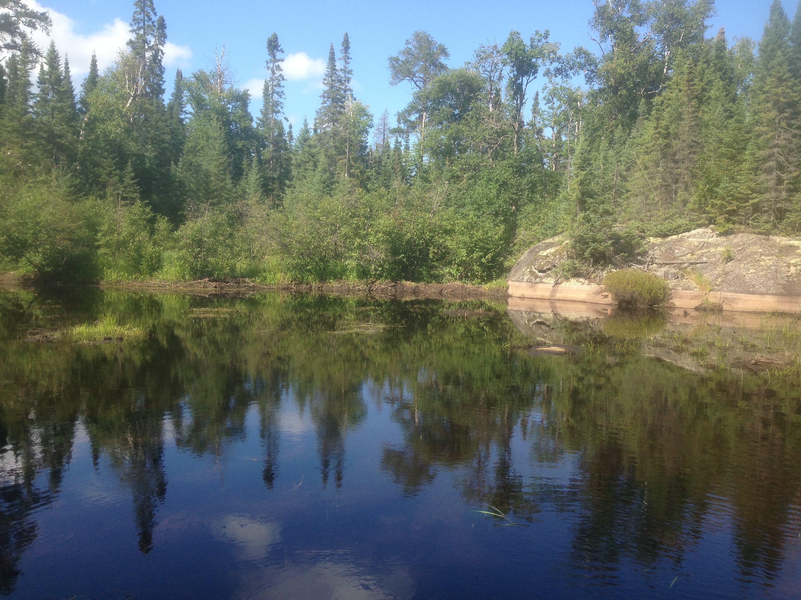
Looking across the small pond that you just crossed on the way to Fool Lake. Directly across the pond, to the left of the rock outcrop, is a beaver dam. Below this beaver dam is the "Mud Hole".
A view along the creek upstream of the beaver pond. This is another beaver dam (foreground) that you must liftover. Lots of logs to work around through this section too. Look for the start of the final bushwhack to your left when you reach the end of navigable water.
You look out on a small bay of Fool Lake after completing the moderately demanding bushwhack. This view is from the very northern tip of Fool Lake.
PADDLING FROM NORTH TIP OF LAKE TO THE JESTER LAKE BUSHWHACK
Paddling from the north tip of Fool Lake over to the Jester Lake bushwhack, which is found just up a creek that drains into the western bay of the lake. Just after entering the creek, look to your right and you can see where a moose (probably) was lying in the grass. Unfortunately never saw the moose. ***********************************************END OF ROUTE***********************************************
PADDLING FROM THE JESTER LAKE BUSHWHACK TO THE SWOLLEN ANKLE LAKE BUSHWHACK
From the creek leading up to Jester Lake, paddle out of the weedy bay and proceed east along the south shoreline of Fool Lake. Paddling back into another small bay at about the middle point of the south shore of the lake, you recon a wetland and tiny creek that could potentially be followed/bushwhacked to Swollen Ankle Lake. This way to Swollen Ankle Lake doesn't appear pleasant. Maybe there is a better route... ***********************************************END OF ROUTE***********************************************
PADDLING FROM SWOLLEN ANKLE LAKE BUSHWHACK TO EAST END AND THEN EXPLORING UP EAST SHORELINE
You start at the bay on Fool Lake's south shore nearest to Swollen Ankle Lake. With steady paddling, you reach the eastern end of the lake. Finally, you continue up Fool Lake's eastern shoreline. ***********************************************END OF ROUTE***********************************************