Fishing: Unknown,but probably northern pike and walleye (since they are in Vern Lake)
Maps: Fisher F-6 and F-12; McKenzie #21
River Depth: Over 5 feet in places
Fire History: June 1996
River Length: About 4 miles. The Vern River flows from Vern Lake to Weird Lake and is a tributary of the Temperance River.
Campsites: None
Wildlife Seen on Visit: Beaver, Ducks
Last Visited: September 24, 2024;
Previous Visit(s): August 12, 2023, June 19, 2022, May 27, 2016
River Elevation: Headwaters at Vern Lake at 1811 feet. The mouth at Weird Lake is at 1754 feet. The Vern River drops 57 feet over four miles (about 14 feet per mile).
Water Clarity: N/A
ROUTES/PORTAGES FROM THE VERN RIVER:
To East Pipe Lake: Walk the 20 rod portage
To Homer Lake: Paddle In
To Vern Lake: Paddle In
To Weird Lake: Paddle In (reachable via unmaintained route from Vern Lake to Weird Lake)
Vern River
Tofte Ranger District
The Vern River is not a maintained BWCA route between Weird Lake and Vern Lake. Upstream of Vern Lake, the Vern River is a maintained route through the BWCA and is easily navigable, with portages present around any non-navigable stretches of water. Downstream of Vern Lake, the river is along an unmaintained route consisting of a series of ponds and flat water stretches, which are connected by 16 short to medium sets of rapids which require either lining the canoe through them or bushwhacking around them. Also along this wild stretch of the Vern River there may be a few beaver dams and downed trees to get past.
The videos shown below show the entire Vern River. The section of river downstream of Vern Lake to Weird Lake was done in August 2023. It is recommended that if you try this route, you don't do it in high water conditions. If the water is high, you will not be able to walk down the rapids (of which there are 16 of them). Except for perhaps three sets of rapids, the rest are almost impossible to bushwhack around as the forest in this area is thick and full of blowdown from recent windstorms. If there has been a recent windstorm that knocks over lots of trees, the river may also be impassable. If the water levels in the river are really low, you can probably still make it through, but you will be walking your canoe through the water a lot more than you see in the videos shown below. There is evidence that perhaps a handful of groups travel the route between Vern Lake and Weird Lake each year.
The river almost certainly contains some northern pike and walleyes, especially for the section of river stretching for about 1 1/2 miles downstream of Vern Lake.
For a couple of miles or so downstream of Vern Lake, fire scars are visible along the river, remaining evidence of the blaze that took place in this area in the late 1990's.
A fire of about 4,450 acres started on June 14, 1996 as a result of a lightning strike. This fire burned from the eastern side of South Temperance Lake toward the southeast. The fire spread along the southwestern corner of Brule Lake, to the west end of Juno Lake and portions of Vern Lake and the Vern River. The fire was mostly out by the end of the month (Hansen, 2007). The fire cost and estimated $1.5 million (Beymer, 2006).
The Vern River seems to have two sources, Homer Lake and either East Pipe Lake or Pipe Lake (more likely Pipe Lake since it is further up the watershed). The Vern River drains into the Temperance River watershed at Weird Lake.
Click on the photos below to see the full resolution image - Use your browsers back button to close photo and return to this page.
PADDLING FROM HOMER LAKE DOWNSTREAM TO THE FIRST PORTAGE
Brief paddle from where the Vern River flows out of Homer Lake to the first portage heading downstream. Homer Lake is one of the sources of the Vern River. Portage downstream back into the Vern River -or- Explore Another Route ***********************************************END OF ROUTE***********************************************
PADDLING THE FROM THE 1ST PORTAGE DOWNRIVER OF HOMER LAKE, DOWNSTREAM TO THE EAST PIPE LAKE PORTAGE
This paddle starts at the south end of the 10-rod portage just downriver of Homer Lake. From that portage, paddle south down the Vern River, staying to the left (east) side of the stream. You'll come to a small inlet where you find the portage to East Pipe Lake. There is sometimes a small beaver dam blocking the entrance to the inlet. Portage to East Pipe Lake -or- Explore Another Route ***********************************************END OF ROUTE***********************************************
PADDLING FROM THE EAST PIPE LAKE PORTAGE UPSTREAM TO THE 1ST PORTAGE THAT IS DOWNRIVER FROM HOMER LAKE
Following the Vern River north towards Homer Lake until reaching the portage. Portage to Homer Lake -or- Explore Another Route ***********************************************END OF ROUTE***********************************************
PADDLING FROM THE 1ST PORTAGE THAT IS DOWNRIVER FROM HOMER LAKE UPSTREAM TO HOMER LAKE
Rather short paddle upstream to Homer Lake. Portage to Homer Lake -or- Explore Another Route ***********************************************END OF ROUTE***********************************************
Traveling the Vern River Downstream from Vern Lake to Weird Lake
PART 1: This is not a maintained route through the BWCA. Be prepared. Travel at your own risk. The distance between Vern Lake and Weird Lake is about 3.9 river miles. Part 1 of this 4-part series covers a distance of about 1.5 miles. Part 1 is the easy flatwater section of the Vern River, just downstream of Vern Lake. This section starts where the river flows out of Vern Lake and ends at the head of the first rapids. There may be a beaver dam at a narrow spot along the river, but there wasn't one there as of August 2023. Along this stretch of the Vern River, you'll see signs a fire that burned about 4,450 acres along the north bank of the river (right side if you are paddling downstream). The fire started on June 14, 1996 as a result of a lightning strike. This fire burned from the eastern side of South Temperance Lake toward the southeast. The fire spread along the southwestern corner of Brule Lake, to the west end of Juno Lake and also burned the western/north half of the Vern Lake shoreline. The fire was mostly out by the end of that month (Hansen, 2007). The fire cost and estimated $1.5 million (Beymer, 2006).
PART 2: Part 2 of this 4-part series covers a distance of about 0.6 miles. In this section we encounter the first six sets of rapids. It is possible to bushwhack rather easily around the first two sets of rapids, but it is probably easier to just walk your canoe down them. Note that by mid-summer, the rocks lining the bottom of the river are slicker than pressed owl snot with algae, so you'll want to take each step carefully as you make your way down the rapids. At the end of this video just above the six rapids, there is a nice place to pull over (if water levels are too high) and land your canoe, if you need a break.
The flat section of rock (the "rest area") makes for a nice place to have lunch before you continue your travels down the river. The view is looking upriver from the head of the sixth set of rapids.
View downstream from the "rest area" at the top of the sixth set of rapids. In August 2023, there was a small beaver dam here. If the beaver dam is gone, these rapids likely get a bit longer since the river upstream of the dam will be shallower.
PART 3: This video covers a distance of about 1.1 miles. This section begins at the head of the 6th rapids and concludes at the tail of the 12th rapids. The rapids become longer on average as you make your way downriver, so things don't get easier. Also, if you are keeping count, at the head of the 10th rapids, there looks to be a portage landing on the right side of the river. This portage doesn't lead anywhere other than into a thicket of brush and downed timber. So you can just walk the 10th set of rapids.
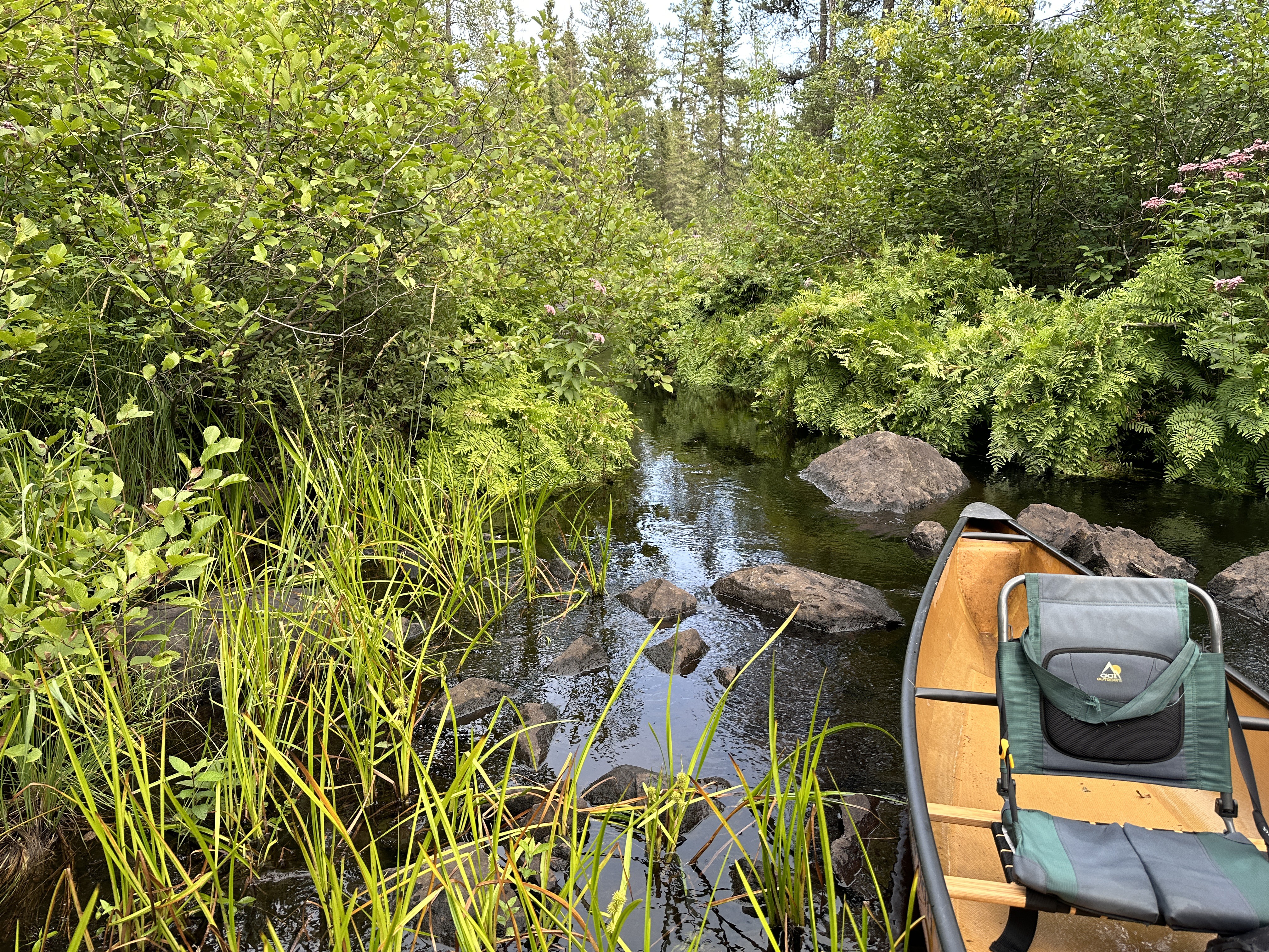
This is near the top of the 15th set of rapids. The river is narrow here and the forest encroaches closely to the river.
PART 4: This video shows the final 0.7 miles of the Vern River before reaching its mouth at Vern Lake. This section begins at the head of the 12th rapids and concludes at the mouth of the Vern River at Weird Lake. There is a viable portage found on the left side of the river at the top of the 13th set of rapids. The 13th rapids are probably one of the most difficult along the route, so the portage is very useful here. Once through the 16th set of rapids, the river flattens out and flows through wetlands. For several hundred feet, the river passes through tall marshland grasses with a channel no wider than your canoe. If water levels are really low, this could be a challenging section, as you will have to wade through mud and silt or otherwise find a path along the shoreline.
Soon after you exit the 16th and last set of rapids (which are rather short), you enter the river of grass. View downriver not far upstream of Weird Lake.
Traveling the Vern River Upstream from Weird Lake to Homer Lake/East Pipe Lake
Most of the section from Weird Lake upstream to Vern Lake is missing in this section.
Click on the photos below to see the full resolution image - Use your browsers back button to close photo and return to this page.
A view of the lower reaches of the Vern River. This is just upstream from where the river flows into Weird Lake. The river can be paddled without interruption for about a quarter-mile or so from Weird Lake before running into obstructions (aka rapids).
From it's mouth at Weird Lake, you take a quick paddle into the lowest reaches of the Vern River to take a look around.
FOR APPROXIMATELY THE NEXT TWO MILES HEADING UPSTREAM, THE VERN RIVER IS NOT A MAINTAINED ROUTE, HOWEVER IT CAN BE PASSABLE IF WATER LEVELS ARE GOOD. THROUGH THIS ROUGHLY TWO MILE STRETCH ARE SPACED 16 SMALL RAPIDS, A FEW BEAVER DAMS AND PERHAPS SOME DOWNED TREES THAT LIE ACROSS THE WIDTH OF THE RIVER. TO GET THROUGH THIS SECTION MOSTLY REQUIRES LINING YOUR CANOE UP THE RAPIDS AND IN A FEW CASES, BUSHWHACKING. IF YOU DECIDE TO TRAVEL THROUGH THIS AREA, MAKE SURE YOU ARE KNOWLEDGEABLE AND WELL PREPARED.
THE VERN RIVER JUST BEFORE REACHING VERN LAKE
Paddling around the small island that can be found where the Vern River flows out of Vern Lake.
PADDLING ACROSS VERN LAKE, WHICH THE VERN RIVER FLOWS THROUGH
The Vern River flows through Vern Lake, entering in the southeast and flowing out of the lake just across from the Whack Lake portage.
PADDLING UPSTREAM FROM VERN LAKE TO THE FIRST PORTAGE
There is a short section where you will likely have to get out of your boat and "push", depending on water levels.
PORTAGE OF 8-RODS UPSTREAM TO THE VERN RIVER
Easy portage around a set of rapids. The landing on the upstream end of this portage isn't so swell.
AS THE VERN RIVER NEARS ITS HEADWATERS, IT SPLITS IN TWO. THIS IS BECAUSE THE RIVER BEGINS IN TWO DIFFERENT LAKES 1) HOMER LAKE OR 2) EAST PIPE LAKE
1) HEADING TO HOMER LAKE:
PADDLING UPSTREAM FROM THE 8-ROD PORTAGE TO THE 4-ROD PORTAGE (NEAR HOMER LAKE)
THIS VIDEO COMING SOON...
PORTAGE OF 4-RODS UPSTREAM TO THE VERN RIVER
The tail end of the short stretch of mild rapids that this portage is used to bypass.
This portage is so short, it is guaranteed to be easy.
PADDLING UPSTREAM FROM THE 4-ROD PORTAGE TO HOMER LAKE
A scenic section of the Vern River just before reaching Homer Lake.
2) HEADING TO EAST PIPE LAKE:
PADDLING UPSTREAM FROM THE 8-ROD PORTAGE TO THE 20-ROD PORTAGE TO EAST PIPE LAKE
The river widens up and forms a small lake. The Vern River feeds this wide section from two different directions. If you head to the right as you paddle upstream, you will come to the East Pipe Lake portage. If you were to go left, you are traveling in the direction of Homer Lake. Here will will go right, East Pipe Lake.
PORTAGE OF 20-RODS UPSTREAM TO EAST PIPE LAKE
Portage gets waterlogged on the East Pipe Lake end because of beaver activity. This is a very pretty area, so take a break from portaging here and click a few photos.
A look at the rapids along the Vern River, as seen from the portage leading to East Pipe Lake.
Route Connections for Vern River
You can paddle into the Vern River from either Weird Lake, Vern Lake, Homer Lake or East Pipe Lake. The river is passable (with maybe a beaver dam or two) for about 1.5 miles downstream from Vern Lake. Traveling the remaining two miles or so until reaching Weird Lake requires lining, walking or bushwhacking around 16 stretches of rapids. Most of these rapids are short in length, but a couple are perhaps 1/8th mile long. A beaver dam or two, as well as logs and rocks may also require you to get out of your canoe to bypass them. This Vern River between Vern Lake and Weird Lake is not an official route through the BWCA.