ROUTES/PORTAGES FROM SEA GULL LAKE:
To Alpine Lake (north route): Walk the 30 rod portage
To Alpine Lake (south route): Walk the 100 rod portage
To Grandpa Lake: Walk the 185 rod portage
To Gull Lake: Walk the 35 rod portage
To Paulson Lake: Walk the 410 rod portage
To Rog Lake: Walk the 20 rod portage
Sea Gull Lake
Gunflint Ranger District
SEA GULL LAKE CAMPSITES: Campsite 1 (#501): Located on forested island just SW of Fishhook Island Campsite 2 (#457): Easternmost of the three campsites located on the eastern side of Three Mile Island Campsite 3 (#458): The middle of the three campsites located on the eastern side of Three Mile Island
Campsite 4 (#459): Westernmost of the three campsites located on the eastern side of Three Mile Island Campsite 5 (#442): This campsite is on an island south of the center of Three Mile Island Campsite 6 (#444): Located on island just north of the Paulson Lake portage
Campsite 7 (#456): This campsite is situated on the fairly large island just east of the north end of Three Mile Island
Campsite 8 (#2070): The campsite is on the west side of the largest of several islands just east of the northern end of Three Mile Island
Campsite 9 (#500): This is the second campsite from the south end of Three Mile Island. It is on the eastern side of the island
Campsite 10 (#443): This is the southernmost campsite on Three Mile Island
Campsite 11 (#445): The campsite is located on the small island just off the southwest end of Three Mile Island
Campsite 12 (#447): The southernmost of two campsites located on the island just west of the south end of Three Mile Island
Campsite 13 (#446): The northernmost of two campsites located on the island just west of the south end of Three Mile Island
Campsite 14 (#448): This is the first campsite west of the Paulson Lake portage
Campsite 15 (#450): This is the westernmost of the two campsites on the island located about 1 mile due east of the Rog Lake portage
Campsite 16 (#449): This is the easternmost of the two campsites on the island located about 1 mile due east of the Rog Lake portage
Campsite 17 (#451): This is the first campsite east of the Rog Lake portage
Campsite 18 (#454): This is the first campsite north of the Rog Lake portage
Campsite 19 (#452): This is the second campsite north of the Rog Lake portage
Campsite 20 (#453): This is the third campsite north of the Rog Lake portage
Campsite 21 (#455): This is the fourth campsite north of the Rog Lake portage and is situated on the tip of the point
Campsite 22 (#502): This is the third campsite south of the Alpine Lake portage
Campsite 23 (#460): This is the second campsite south of the Alpine Lake portage
Campsite 24 (#461): This is the first campsite south of the Alpine Lake portage
Campsite 25 (#462): This campsite is on the small island just east of Alpine Lake portage
Campsite 26 (#463): This campsite is located just over a mile to the northeast of the Alpine Lake portage on a small island
Campsite 27 (#464): This is the first campsite along the shoreline north of the Alpine Lake portage
Campsite 28 (#465): This is the second campsite along the shoreline north of the Alpine Lake portage
Campsite 29 (#462): The campsite is on the small island just northeast of BWCA Campsite 460
Campsite 30 (#466): The campsite is located on the small island just east of BWCA Campsite 465
Campsite 31 (#467): This campsite is located on the small island about a half-mile east of BWCA Campsite 465
Campsite 32 (#468): This is the third campsite located south and west along the north shoreline of Sea Gull Lake from the Grandpa Lake portage
Campsite 33 (#469): This is the second campsite located south and west along the north shoreline of Sea Gull Lake from the Grandpa Lake portage
Campsite 34 (#472): This is the first campsite located south and west along the north shoreline of Sea Gull Lake from the Grandpa Lake portage
Campsite 35 (#470): This is the northernmost of two campsites situated on a large island just south of BWCA Campsite 469
Campsite 36 (#471): This is the southernmost of two campsites situated on a large island just south of BWCA Campsite 469
Campsite 37 (#2133): Campsite is on the large island in this area of the lake, that is just west of the southern end of Three Mile Island
Campsite 38 (#473): This is the southernmost of two campsites along the west side of Three Mile Island
Campsite 39 (#474): This is the northernmost of two campsites along the west side of Three Mile Island
Campsite 40 (#477): Campsite is on the island just off the north end of Three Mile Island
Campsite 41 (#475): Campsite is on the narrow island just west of the north end of Three Mile Island
Campsite 42 (#476): Campsite is located on a small is just west of roughly the mid-point of Three Mile Island
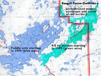
Sea Gull Lake (Entry Point 54) is a popular starting point to launch trips into the northeastern Boundary Waters Canoe Area Wilderness (BWCA). The entry point offers several route options radiating outward from the western part of the lake. The lake is renowned for its 100+ islands, interesting rock formations (including one with a badly faded pictograph), decent fishing, and versatile wilderness experience suitable for a wide range of paddlers. The eastern portion of the lake permits limited motor use (up to 10 horsepower), while the western areas are paddle-only, preserving a quieter backcountry atmosphere. Sea Gull Lake is defined by its dramatic shoreline and varied terrain. The most notable feature is the series of 80-foot cliffs known as the Palisades along the north shore. The lake’s many islands, sheltered coves, and sandy-bottomed bays provide both scenic beauty and protection from wind.
Motorboats are allowed in the eastern part of Sea Gull Lake, east of Three Mile Island. Here is a map:
Extensive Recent Fire History:
2004 Alpine Lake Fire:
The Alpine Lake Fire was a wildfire ignited by lightning on July 30, 2005, in the northeastern part of the BWCAW near the Gunflint Trail between Alpine Lake and Seagull Lake in northeastern Minnesota. It was the first major wildfire in that blowdown-affected area following the large 1999 windstorm that toppled millions of trees, leaving abundant fuel on the ground. The fire burned approximately 1,400 acres of wilderness forest, primarily between Alpine Lake, Seagull Lake, Red Rock Lake, and Grandpa Lake.
2006 Cavity Lake Fire:
The fire was started by lightning on July 13–14, 2006, near Cavity Lake in the northeastern BWCAW, close to the Gunflint Trail region of Minnesota’s Superior National Forest. It initially burned in heavy blowdown timber left over from the 1999 “Boundary Waters blowdown” storm, which created abundant dry fuel. The blaze spread rapidly under dry, windy conditions, expanding from a few hundred acres to thousands within days. Ultimately, the Cavity Lake Fire burned approximately 32,000 acres (roughly 50 square miles) of forest, making it the largest fire in the BWCAW in over a century up to that point.
2007 Ham Lake Fire:
The Ham Lake Fire ignited on May 5, 2007, on the northwest side of Ham Lake, very near to U.S. Forest Service Campsite #550. The blaze was human-caused, beginning from an unattended campfire, then jumping the Cross River and spreading through the forest to the west/northwest. Dry conditions following a winter with little snowpack combined with strong winds and the heavy fuel loads leftover from the 1999 blowdown resulted in a rapid expansion of the fires footprint. The fire expanded to over 10,000 acres in just a couple days. It was the second largest fire in the last century, eclipsed only by the massive 100,000 acre Pagami Creek fire of 2011. In sum, the Ham Lake Fire burned around 76,000 acres, with half of the burn occurring in Minnesota and the other half in Ontario, Canada.
The lake is well known for good fishing opportunities, especially for walleye, lake trout, smallmouth bass, and northern pike. Moose are occasionally sighted in the surrounding area, along with a variety of other Northwoods wildlife.
As a large and relatively open lake, Sea Gull Lake can become challenging in strong winds. Trip planning should take wind forecasts into account, and early departures are often advisable to ensure safer travel conditions.
The portage from Sea Gull Lake to Paulson Lake is very scenic, with several views of open wetlands along its route. However, the portage is also a real bruiser, being one of the most difficult carries in the BWCA. The portage takes you from the relatively busy Sea Gull Lake to one of the least traveled parts of the Boundary Waters.
The hydrologic flow into the lake is from Sea Gull Creek on the east end of the lake. The flow is mostly from Alpine Lake at the west end of Sea Gull Lake. The water from Sea Gull Lake flows north via the Sea Gull River into Saganaga Lake.
Click on the photos below to see the full resolution image - Use your browsers back button to close photo and return to this page.
PADDLING FROM THE BWCA ENTRY POINT 54 LANDING TO BWCA CAMPSITE 501
Paddling generally southwest from the entry point landing to the campsite. BWCA Campsite 501 is located on a small island just southwest of Fishhook Island. Visit BWCA Campsite 501 -or- Explore Another Route **********************************************END OF ROUTE***********************************************
PADDLING FROM BWCA CAMPSITE 501 TO BWCA CAMPSITE 457
Traveling southwest down the eastern side of Three Mile Island to BWCA Campsite 457, which is located on a point. Visit BWCA Campsite 457 -or- Explore Another Route **********************************************END OF ROUTE***********************************************
PADDLING FROM BWCA CAMPSITE 457 TO BWCA CAMPSITE 458
Briefly paddling westbound to the campsite, which is situated just a short distance down the shoreline from the campsite you just left. Visit BWCA Campsite 458 -or- Explore Another Route **********************************************END OF ROUTE***********************************************
PADDLING FROM BWCA CAMPSITE 458 TO BWCA CAMPSITE 442
This route takes you nearly straight south across the wide channel separating Three Mile Island from the mainland. There is a small island just off the shoreline of the mainland where the next campsite is located. The campsite is on the south side of the island. Visit BWCA Campsite 442 -or- Explore Another Route **********************************************END OF ROUTE***********************************************
PADDLING FROM BWCA CAMPSITE 442 TO BWCA CAMPSITE 444
Following the south shoreline of Sea Gull Lake towards the southwest. The route ends on the southern side of a small island that is perhaps 2,000 feet north of the Paulson Lake portage. The campsite is on the south side of this island. Visit BWCA Campsite 444 -or- Explore Another Route **********************************************END OF ROUTE***********************************************
PADDLING FROM BWCA CAMPSITE 444 TO THE PAULSON LAKE PORTAGE
Paddling due south from the island campsite for roughly 2,000 feet until reaching the Paulson Lake portage landing, which is a nice sandy beach. Portage to Paulson Lake -or- Explore Another Route **********************************************END OF ROUTE***********************************************
PADDLING FROM THE PAULSON LAKE PORTAGE TO THE BWCA ENTRY POINT 54 LANDING
A fairly long paddle of nearly four miles following the south shoreline of Sea Gull Lake . The route is generally on a northeast heading. Journey ends at the BWCA Entry Point 54 boat ramp. Explore BWCA Entry Point 54 -or- Explore Another Route **********************************************END OF ROUTE***********************************************
Route Connections for Sea Gull Lake
From Sea Gull Lake you can portage to Alpine Lake (two different portages), Grandpa Lake, Gull Lake, Paulson Lake and Rog Lake. BWCA Entry Point 54 is located on the eastern end of this large, sprawling lake.