BOWER TROUT LAKE CAMPSITES: Campsite 1 (#780): Middle of the north shoreline Campsite 2 (#781): On the south shore of the lake
The first thing you will likely notice upon arrival at Bower Trout Lake from the entry point parking lot is the prominent hill rising to the south across the lake. That is Brule Mountain. It has three peaks. The middle peak which you can see to the left from the entry point canoe landing is highest and is 2,226 feet (583 feet above Bower Trout Lake). This central peak is just slightly outside of the BWCA. The lower and slightly more distant peak to the right is 2,189 feet (this peak is in the BWCA). Another peak lies to the left of the central peak, but you have to be out on the lake to get a view of it (and its not quite as high at about 2,120 feet). Brule Mountain is probably the 10th highest peak in Minnesota.
1) Eagle Mountain - 2301 feet (Highest point in Minnesota. Highest point for over 500 miles in any direction.)
2) *Point 2266 (About 3.25 miles E/SE of Bower Trout Lake at 47.9297, -90.3710)
3) Point 2260 (Just east of State Lake at 47.97489,-90.51954)
4) Point 2246 (0.85 northwest of State Lake at 47.98573,-90.55236)
5) Gaskin Mountain – 2245 feet (Located at 47.97884,-90.46973)
6) Point 2244 - (0.27 miles south of Winchell Lake and 0.75 miles NE of Tremble Lake at 47.98916,-90.57912)
7) Area of 2,240 feet - (Just west of Point 2246 at 47.9859, -90.5613)
8) *Lima Mountain - 2238 feet (Located at 47.9868, -90.4037)
9) *Point 2238 - (Just southwest of Point 2266 at 47.9261, -90.3787) 10) ***Brule Mountain - 2226 feet (Just south of Bower Trout Lake at 47.9303, -90.4469)
11) Point 2223 – (Just northwest of Bunga Lake and just east of the east end of Winchell Lake at 47.9916, -90.5273)
12) Point 2223 – (North of Dislocation Lake and due east of Gaskin Mountain summit at 47.9783, -90.4426)
13) *Point 2223 – (Just east of Thrasher Lake and due west of Mit Lake at 47.8949, -90.4823)
14) *Area of 2220 feet - (Just south/southwest of Lima Mountain summit and located at 47.9833, -90.4056)
15) Area of 2220 feet - (Just west of Thrasher Lake at 47.8946, -90.5124)
16) Area of 2220 feet - (Just east of Point 2212 and just northwest of Latern Lake at 47.9819, -90.5071)
17) Area of 2220 feet - (Just east of Eagle Mtn. - this is peak visible from Whale Lake that many mistake as Eagle Mountain - 47.8983, -90.5480)
18) Point 2212 – (Just southeast of Bunga Lake at 47.9824, -90.5131)
19) *Point 2211 - (Just northwest of Thrush Lake and just southeast of Hand Lake at 47.8986, -90.5044)
20) Area of 2200 feet - (Just east of Gaskin Mountain summit at 47.9782, -90.4610)
21) Area of 2200 feet - (Just east of Thrasher Lake and just west of Point 2223 at 47.8947, -90.4864)
22) Area of 2200 feet - (Just east of Gasket Lake at 47.9705, -90.7365) * = Indicates the point is just outside of the BWCA
**This list may have an omission, but it is surely close. Will be updated if new information becomes available.
***Brule Mountain (it's highest peak) is right on the BWCA boundary line.
The 20 highest points are all found in an area of Minnesota called the Misquah Hills. These hills are roughly centered around Misquah Lake. Fourteen of these high points are in the Boundary Waters Canoe Area.
Point 2260: Means that the location has been measured by a survey crew to that exact height. There is often an official benchmark at these spots.
Area of 2220 feet: This means that the area has been measured by a survey crew to at least that height.
The lowest point in Minnesota is the shore of Lake Superior at 600 feet.
The highest point in Lake County, Minnesota is just over 2,080 feet on Stony Tower Hill. Only Cook County, Minnesota has elevations that exceed that height.
Both portages to/from Bower Trout Lake are relatively easy and of medium length. Note that the portage to the entry point IS NOT on the far east end of the lake. It is actually along the northeast shoreline (near the gravel pit shown on maps). Most maps show the portage in the wrong place. If the water levels are really low, the start of the portage to Marshall Lake can be a bit of a mudhole.
There are two campsites on Bower Trout Lake. Neither campsite is particularly inviting.
The South Brule River flows into Bower Trout Lake just east of the Marshall Lake portage. The river exits the lake out its very eastern end.
An old railroad grade passes along much of the north shoreline of Bower Trout Lake. This railway was a spur of a larger rail system owned by the General Logging Company. It was in use until the early 1930's. The rail line went through the area where the parking area is now located at BWCA Entry Point 43 (Beymer, 103).
On some older maps, including USGS 7.5 topographic maps, Bower Trout Lake is referred to as Lower Trout Lake. This may have been its original name. Bower is defined as a "pleasant shady place", "an anchor carried at the bow of a ship" or "an attractive dwelling". The lake is lined with many large cedar trees.
References:
Beymer, Robert, Boundary Waters Canoe Area – Volume 2 – Eastern Region (Berkeley: Wilderness Press, 2006), 89, 91, 94, 103, 111.
Pauly, Daniel, Exploring the Boundary Waters (Minneapolis: University of Minnesota Press, 2005), 284, 285.
Click on the photos below to see the full resolution image - Use your browsers back button to close photo and return to this page.
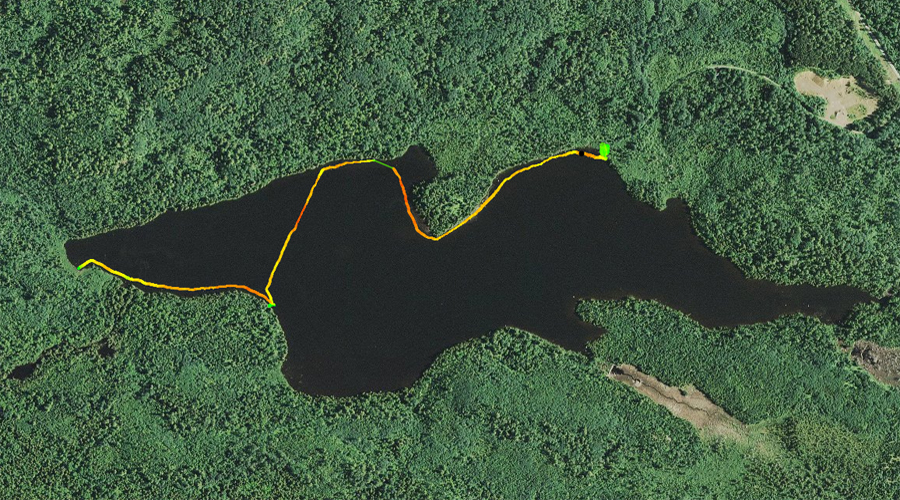
PADDLING FROM THE BWCA ENTRY POINT 43 PORTAGE TO THE MARSHALL LAKE PORTAGE
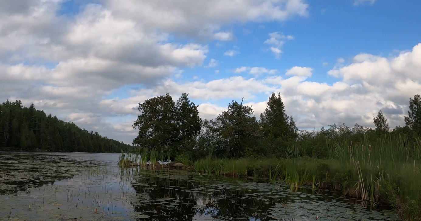
Looking toward the southeast from the campsite on the north shore of Bower Trout Lake. The eastern most of the three peaks of Brule Mountain is visible in the far distance just left of center. The nearer and highest central peak is visible to the right. On the left is the point that juts out from the north shore of Bower Trout Lake.
A winding paddle that begins at the BWCA Entry Point 43 portage landing. From the landing, you paddle along the north shore and around the lakes north point. Just beyond the point to the west, you continue paddling past the campsite found in that part of the lake. Continuing beyond the campsite, paddle west a little ways and then turn sharply south and paddle across the open lake. After crossing the lake you soon come to the campsite along the south shoreline. Proceed from that campsite westward along the south shore, passing the mouth of the South Brule River. Just beyond where the river flows into the lake, paddle through some aquatic vegetation (mostly lily pads) to the small dock marking the location of the Marshall Lake portage.
Westerly view down the north shoreline of Bower Trout Lake. The western most peak of Brule Mountain is just visible to your left. The moutain has three distinct peaks.
A good view of Brule Mountain from the north side of the lake. You are looking south/southeast. Portage to Marshall Lake -or- Explore Another Route ***********************************************END OF ROUTE***********************************************
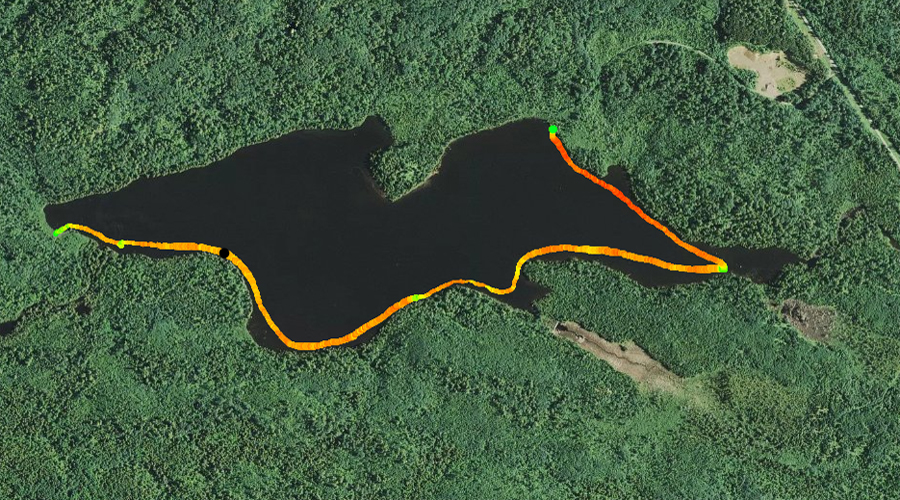
PADDLING FROM THE MARSHALL LAKE PORTAGE TO THE BWCA ENTRY POINT 43 PORTAGE
The west end of Bower Trout Lake is very shallow and covered with lily pads and other aquatic vegetation. This perspective is from the Marshall Lake portage landing.
Looking roughly eastward, just east of the Marshall Lake portage. This is the marshy area where the South Brule River flows into Bower Trout Lake. It flows into the lake through several channels that are hidden amongst the vegetation.
Paddling along the south shore of Bower Trout Lake, heading eastward, beginning at the Marshall Lake portage. Shortly after leaving the portage you pass the mouth of the South Brule River. It flows into the lake via several small channels. Rounding the "rounded" point in the southwest part of the lake, you pass the campsite located there. You continue nearly to the far eastern tip of the lake where the South Brule River flows out. You then turn abruptly back toward the west and follow the north shoreline of the lake to the BWCA Entry Point 43 portage landing along the northeast shoreline.