KELSO LAKE CAMPSITES: Campsite 1: This is the south most campsite along the east shore of the lake. Campsite 2: This is the middle of the three campsites along the east shore of the lake. Campsite 3: This is the northern most campsite along the east shore of the lake.
Similar to lakes nearby (i.e. Sawbill), the majority of the trees here are not that tall. The area around Kelso Lake was included in the logging operations that persisted here until the 1960's. So this is a relatively young forest. There is an occasional tree that really stands above the rest because it was spared by the loggers for one reason or another. The portage between Kelso Lake and Alton Lake used to be a railway. This railway was disassembled and the hand pushed railcars were removed in 1965 (Hanson, 2007). However, some of the old rail sections can still be found along the portage. Check out the book "Sawbill: History and Tales" by Mary Alice Hanson, particularly pages 209- 211 for historical information about Kelso Lake.
Kelso Lake is a crossroads of sorts with routes to the north, south and east. It is linked to two very busy lakes (Alton Lake and Sawbill Lake) and it is near to BWCA Entry Point 38 on Sawbill Lake. There won't be a lot of solitude here, if that is what you seek. The route to the south into Alton Lake is over a very easy and short portage. The way into Sawbill Lake involves a scenic paddle along the Kelso River and a simple portage of 13 rods into Sawbill Lake. The northern route out of Kelso Lake is not so easy.
There is little current paddling up or down the Kelso River between Lujenida Lake and Kelso Lake. Lujenida Lake and Kelso Lake are both at 1801 feet of elevation above sea level, so the river connecting them is indeed smooth. There might be some beaver activity along this section of the Kelso River. If you go up to Lujenida Lake, you will find no campsites. The only route is over the 480 rod portage up to Zenith Lake. Don't wait until late in the day to begin this journey.
There are three campsites on Kelso Lake, all along the eastern shoreline. The south one is probably the nicest. The middle one is probably the second best and the north campsite is probably the least attractive. Even the northern campsite is reasonable though, albeit small.
Kelso Lake supports northern pike (abundant but undersized) and perhaps some smallmouth bass and bluegill.
Kelso Lake is a wide spot of the Kelso River. Water flows into the lake from the Kelso River at the north end of the lake. The Kelso River exits the lake along the east shoreline about midway down the lake. The Kelso River continues until it ends at Sawbill Lake.
References:
Beymer, Robert, Boundary Waters Canoe Area – Volume 2 – Eastern Region (Berkeley: Wilderness Press, 2006), 53, 78, 86, 133, 140, 151.
Hansen, Mary Alice, Sawbill: History and Tales (Tofte: Sawbill Press, 2007).
Pauly, Daniel, Exploring the Boundary Waters (Minneapolis: University of Minnesota Press, 2005), 245, 257.
Click on the photos below to see the full resolution image - Use your browsers back button to close photo and return to this page.
PADDLING FROM WHERE THE KELSO RIVER FLOWS OUT OF THE LAKE TO THE ALTON LAKE PORTAGE
Paddle out of the Kelso River after heading upstream and turn left to head south down Kelso Lake. Stay to the west side of the lake until reaching the Alton Lake portage on Kelso Lake's southern end. Portage to Alton Lake -or- Explore Another Route ***********************************************END OF ROUTE***********************************************
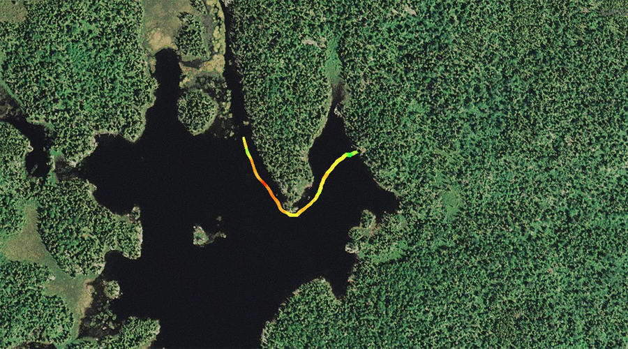
PADDLING FROM ALTON LAKE PORTAGE TO THE SOUTH CAMPSITE ON THE EAST SHORELINE
Looking northeasterly from the entry point landing.
Paddling up the eastern shoreline of Kelso Lake from the Alton Lake portage to the lakes most southern campsite. All the campsites on Kelso Lake are located on the east side of the lake.
View to the southwest from the southern most of the three campsites along the eastern shoreline of Kelso Lake. Visit the Campsite -or- Explore Another Route ***********************************************END OF ROUTE***********************************************
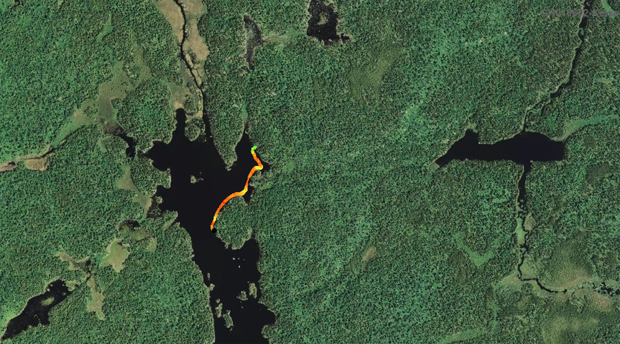
PADDLING FROM THE SOUTH CAMPSITE TO THE MIDDLE CAMPSITE ALONG THE EAST SHORELINE
Wider part of the lake not far north of the southern most of the three campsites found along the east shoreline of Kelso Lake. Your view here is generally northward.
Heading north up the east shore of Kelso Lake from the lakes south most campsite, to the middle of the lakes three campsites. Strong winds making the paddling difficult.
Looking generally to the west from the middle of the three campsites. This was a windy day, so you can see the white froth streams along the lakes surface. Visit the Campsite -or- Explore Another Route ***********************************************END OF ROUTE***********************************************
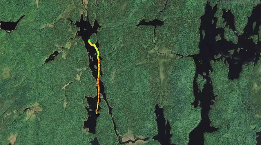
PADDLING FROM THE MIDDLE CAMPSITE TO THE NORTH MOST CAMPSITE ALONG THE EAST SHORELINE
Short paddle from the middle of the lakes three campsites, north along the eastern shoreline into the northeast bay of Kelso Lake. This is where the northern most campsite on the lake is located. Kind of secluded.
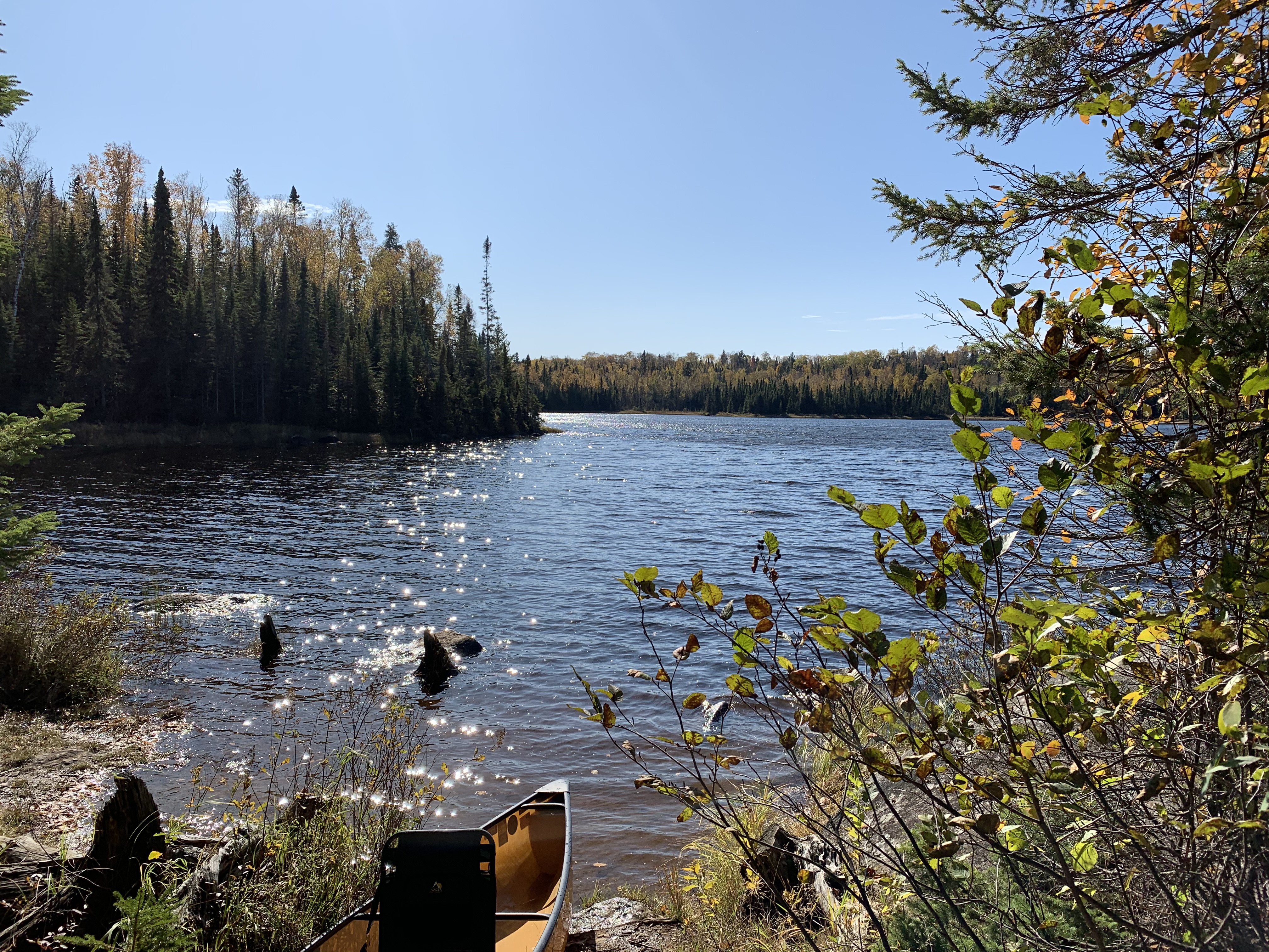
Looking to the southwest from the northern most campsite on the lake. This campsite is back in a small bay, that is just south of where the Kelso River flows into the lake from the north. Visit the Campsite -or- Explore Another Route ***********************************************END OF ROUTE***********************************************
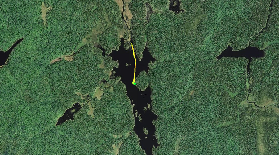
PADDLING FROM THE NORTH CAMPSITE NORTHBOUND INTO THE KELSO RIVER
It's a short paddle out of the bay. At the point near the bays entrance, you turn right (north) and paddle into the Kelso River headed upstream.
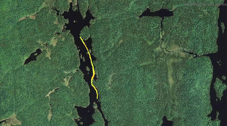
PADDLING FROM THE KELSO RIVER SOUTHBOUND TO THE MIDDLE CAMPSITE
(Note: Follow this route if continuing downstream along the Kelso River)
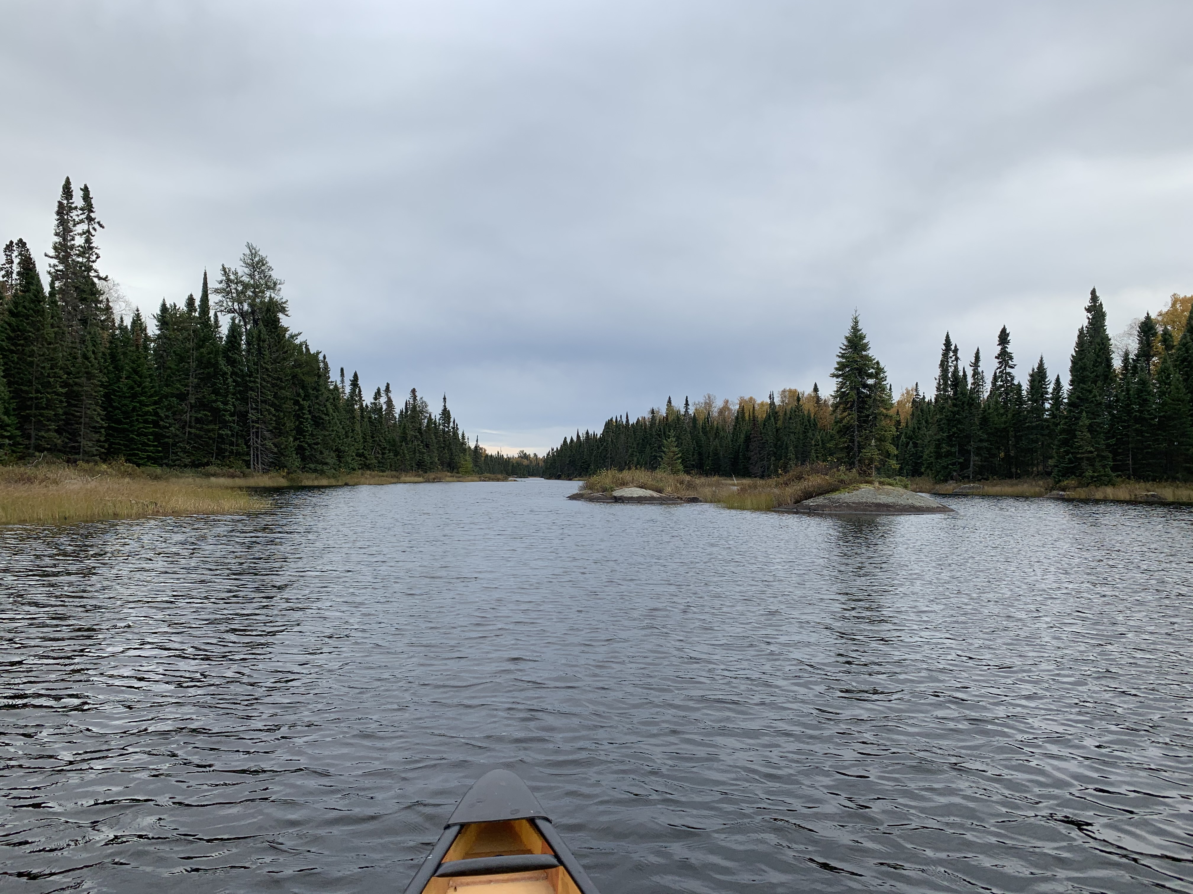
Kelso River where it flows into the north end of Kelso Lake.
Paddling along the eastern shoreline of Kelso Lake from where the Kelso River enters the north end of the lake, to the middle of the lakes three campsites.
PADDLING FROM THE MIDDLE CAMPSITE SOUTHBOUND INTO THE KELSO RIVER (Note: Follow this route if continuing along the Kelso River)
After stopping at the middle of the three campsites along Kelso Lake's eastern shoreline, continue southward through Kelso Lake and enter the Kelso River (heading downstream).
The Kelso River resumes here as it flows out of Kelso Lake toward Sawbill Lake. Paddle into the Kelso River -or- Explore Another Route ***********************************************END OF ROUTE***********************************************