River Elevation: Headwaters at Mountain Lake at 1646 feet. Mouth at Lake Superior at 602 feet. Average of about 21 feet per mile of elevation loss.
Water Clarity: N/A
ROUTES/PORTAGES FROM THE PIGEON RIVER:
To South Fowl Lake: Walk the roughly 400 rod portage - The Fowl Portage
To Lake Superior: Walk the 2,720 rod portage - The Grand Portage
Pigeon River
Gunflint Ranger District
If you are planning to paddle the Pigeon River, the first thing you want to check is the river flow. Here is a hydrograph showing the Pigeon Rivers current flow rate in cubic feet per second. For the best paddling conditions, you want a flow rate of between 100 cfs and 500 cfs. It's the thin black line in the graph that shows the current flowage rate. Below 100 cfs, you can expect lots of boulders to be exposed in the river, particularly in the area known as the English Rapids (which are located where the Swamp River flows into the Pigeon River). Below 100 cfs you will have to walk your canoe through some of this stretch. Above 500 cfs and the river current becomes faster and potentially more dangerous.
Allow yourself about four hours to paddle from the Pigeon River end of The Fowl Portage to Fort Charlotte. Also, The Fowl Portage itself is tough, so give yourself two hours to complete that. There are not a lot of places to camp along the Pigeon River, so make sure you have enough daylight left to make the trip.
If you are planning to head upstream from Fort Charlotte to South Fowl Lake, it is best to do this trip when the flow rate of the river is below 250 cfs. This will make it easier to paddle against the current. Also you will have to walk your canoe up the two sections of Class 1 rapids, and doing this in high water would be difficult. Allow about six hours to paddle from Fort Charlotte to the start of The Fowl Portage.
The mouth of the Pigeon River may have been first reached by Europeans around 1660 by two Frenchman named Medard Chouart sieur des Groseilliers and Pierre Radisson.
References:
Bolz, J. Arnold, Portage into the Past (Minneapolis: University of Minnesota Press, 1960), 29, 55-64.
Heinselman, Miron, The Boundary Waters Wilderness Ecosystem (Minneapolis: University of Minnesota Press, 1999), 8, 107, 109.
Pauly, Daniel, Exploring the Boundary Waters (Minneapolis: University of Minnesota Press, 2005), 360, 361, 372.
Rom, William N., M.D., Canoe Country Wilderness (Stillwater: Voyageur Press, 1987), 101, 102.
Traveling the Pigeon River (downstream)
Click on the photos below to see the full resolution image - Use your browsers back button to close photo and return to this page.
The Pigeon River starts its journey to Lake Superior where it flows out of the eastern end of Mountain Lake in the Boundary Waters Canoe Area along the U.S.-Canadian border.
From Mountain Lake, the Pigeon River flows a mere 700 feet before emptying into Fan Lake. This short unnavigable stretch of the Pigeon River is bypassed on the American side of the border by the Lesser Cherry Portage. Note that most of the portages along this route are named because they all date back to the fur trading days and thus are along what is known as the historic Voyageurs Route or The Border Route.
Fan Lake is a very small lake and you'll be across it before you can get your paddle wet. On the east end of Fan Lake is the next portage, called the Vaseux Portage to Vaseux Lake (or Muddy Lake). This portage is also on the U.S. side of the border and like the lake, it is muddy.
Vaseux Lake is much like Fan Lake in size and geography. Just to the south of these two small lakes rises a rather impressive mountain (for Minnesota). This is Moose Mountain. Moose Mountain tops out at 2,012 feet. It's summit is nearly 500 feet above these little lakes. From Vaseux Lake there is a longer portage to Moose Lake that parallels the Pigeon River. This is the Great Cherry Portage.
Moose Lake is a large border lake, a bit over 3.5 miles in length running generally west to east/southeast. The west end of the lake is dominated by two large hills standing over the lake. The western hill is Moose Mountain. The other peak is unnamed and rises to an elevation of 1,963 feet (about 480 feet above Moose Lake's surface).
At the east end of Moose Lake is another portage and this one is on the Canadian side of the border. This is the aptly named Moose Portage and it connects Moose Lake and North Fowl Lake.
The Pigeon River next passes through two large lakes: North Fowl Lake and South Fowl Lake. These two lakes are named for the abundant waterfowl that congregate here in the fall before the seasonal migration. Once in South Fowl Lake, you have officially left the Boundary Waters Canoe Area. At the south end of South Fowl Lake you reach another portage. This is The Fowl Portage and it is located on the Canadian side of the river. You find the portage in a small bay to the east of the dam at the south end of South Fowl Lake. This dam dates back to 1934 (Rom, 1987). The Fowl Portage is about 400 rods long and is somewhat rugged. This portage is in place to get around a waterfall and a long strech of rapids that begin at the dam where the Pigeon River flows out of South Fowl Lake.
The rest of this route is along the Pigeon River. Just 900 feet downstream from the end of The Fowl Portage, the Stump River flows into the Pigeon River along the bank on the United States side. This little river is generally navigable upstream to at least the point where The Border Route crosses it via a wooden bridge. That bridge is about 0.8 miles upstream from the Stump River's mouth at the Pigeon River. Expect to encounter some beaver dams.
Another mile or so downstream, again on the U.S. side, Portage Brook flows into the river. This creek is also navigable in its lower reaches, especially in spring when there is sufficient water and no vegetation clogging up the channel. Probably some beaver dams to lift over if you decide to paddle up it for a ways.
Roughly 3 miles further downstream, you reach an area known as the English Rapids. You will want to ensure all your gear is tied down in your canoe at this point, as the chance of tipping your canoe through the next two miles is increased. These are Class 1 rapids that extend for about 0.5 miles. During low water you will likely have to walk your canoe through some spots in this area as the water will be very shallow. There used to be a portage here to bypass these rapids, but it is long gone. This was known as the English Portage and it was on the Canadian side of the river. The English Rapids are found along a section of the Pigeon River between where an unnamed creek flows in on the Canadian side, downstream to just past the mouth of the Swamp River.
After the English Rapids, for the next 0.5 miles you will paddle through brief sections of flat water and short stretches of minor riffles. You then arrive at another short stretch of Class 1 rapids. These rapids are about 100 yards long. After that, it is flatwater until you reach the portage around Partridge Falls.
The Partridge Portage is on the U.S. bank of the river. Partridge Falls Road ends here where this portage begins. The portage is about 80 rods long. Partridge Falls is a series of three drops totalling about 40 feet.
From Partridge Falls, its another 1.6 miles of smooth water paddling to Fort Charlotte. Here is the canoe landing at Fort Charlotte on the U.S. side, just before another set of rapids begin. Do not continue past this landing, as the river turns into a raging cascade and torrent not far downriver from here. From Fort Charlottle, it is about 8.5 miles along The Grand Portage to Fort George on Lake Superior.
Traveling the Pigeon River (upstream)
Click on the photos below to see the full resolution image - Use your browsers back button to close photo and return to this page.
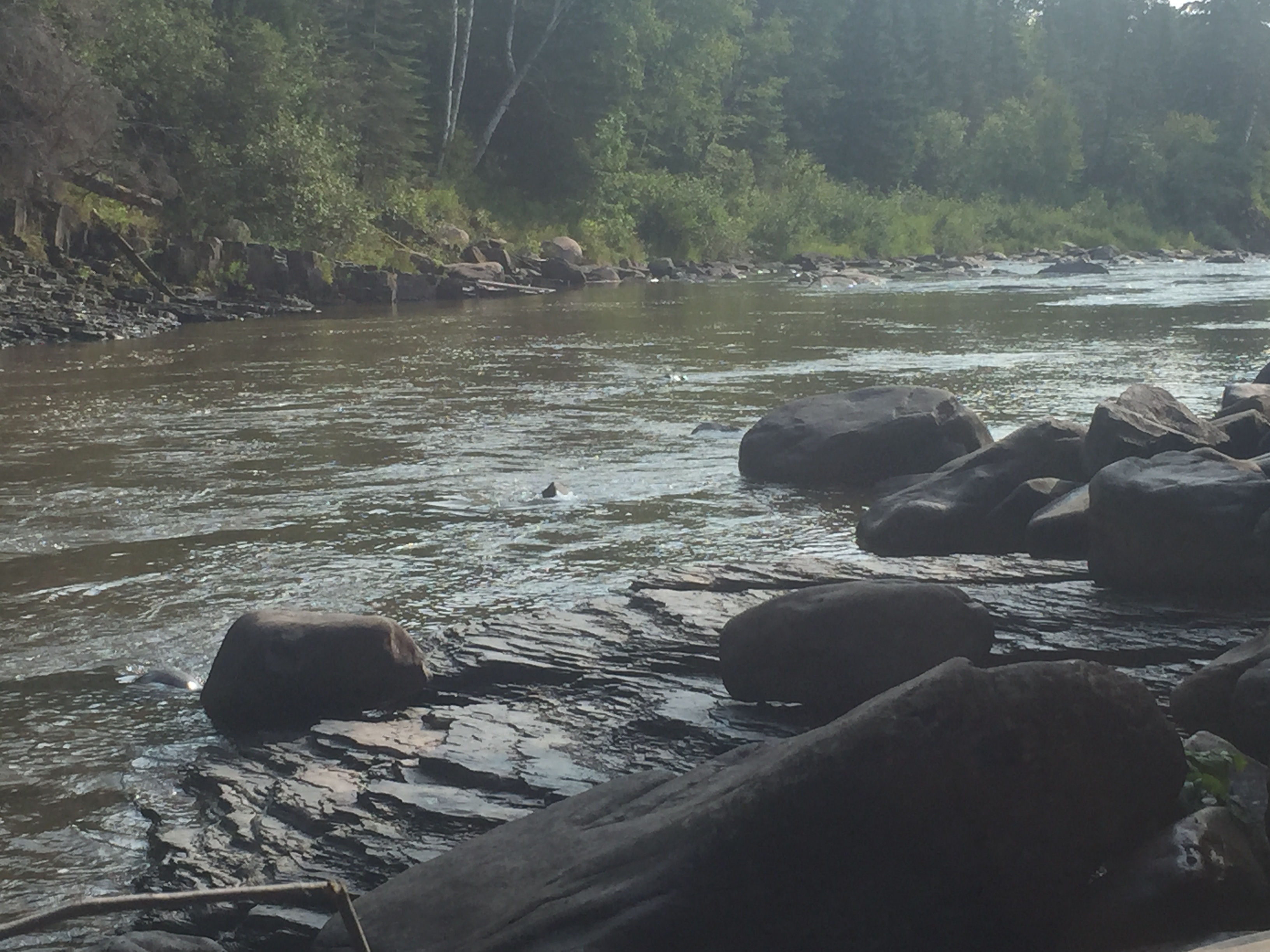
Looking upstream, you can see about one-third of a mile to the next river bend. This is a tranquil stretch of the Pigeon River. This is the view from the Fort Charlotte canoe landing.
The Pigeon River downstream of Fort Charlotte
View downstream from the Fort Charlotte canoe landing. You don't want to continue past the place you are standing. Downstream of Fort Charlotte the river becomes progressively more fierce as it tumbles down several waterfalls and roars through countless stretches of rapids. The boundary of Grand Portage National Monument ends about where you see the river bend in the far distance on the right side of this image. The Cascades start about 1/2 mile downstream from there. They are the first major set of rapids beyond this point. The Cascades stretch for a good mile or so further downriver. Beyond those rapids, the Pigeon River is rarely tame, just less frothy. The river is a seemingly endless series of short flatwater sections punctuated by many Class 1 rapids. Also a major Class 2 or 3 stretch of rapids is mixed in every few miles or so.
About 5 miles downriver of The Cascades, the largest tributary to the Pigeon River flows in on the Canadian side. This is the Arrow River.
For the next 1.2 miles past the mouth of the Arrow River, the Pigeon River makes one and a half sharp backward S-curves. Shortly after the third turn, it goes through a narrow section called The Tunnel, a set of strong rapids and a small waterfall.
Less than a mile downstream of The Tunnel, the Pigeon River flows by what was the former bridge site of Old Highway 61, where the road crossed into Canada. This was also the location of the Town of Pigeon River. The bridge is no longer there and neither is the town, although remnants remain.
The next three miles of the Pigeon River are somewhat mild after you pass the location of the former bridge site. Three more miles downstream the river is paralleled by Canada 593, a paved road that runs very close to the river bank in places. This road runs along the Canadian side of the river all the way to Middle Falls. Also, just after the road starts paralleling the river, the Pigeon River pours over the Horn Rapids. A short but powerful slice of river.
Just over 2 miles below the Horn Rapids, the Pigeon River enters Grand Portage State Park (on the U.S. side), and information and pictures describing that area are shown below:
You are now in Grand Portage State Park: The head of the rapids above Middle Falls. Upstream from this location, the Pigeon River is flat for a while. You can see about another 1/4 mile upriver from where you are standing. Where the river bends in the distance is also the approximate location of the western boundary of Grand Portage State Park. Fort Charlotte, where The Grand Portage ends at the Pigeon River is 14.5 river miles upstream from Middle Falls. The Grand Portage trades 19 river miles, much of it that would have required portaging anway, for a single, relatively flat and straight 8.5 mile portage (2,720 rods). Upriver from this point, until you reach Fort Charlotte, are literally dozens of rapids and several waterfalls that would require portaging. It would be a difficult journey indeed.
More rapids above Middle Falls on the Pigeon River with the top of these rapids visible in the background. This is about 3.5 river miles upstream from Lake Superior.
You can get really close to the Middle Falls. Here you are standing right above them.
Middle Falls of the Pigeon River.
This waterfall is called Middle Falls and is almost two miles upstream from High Falls. Follow the Middle Falls Trail in Grand Portage State Park to reach this location. It is a fairly strenuous hike; it is more difficult than typical state park trails.
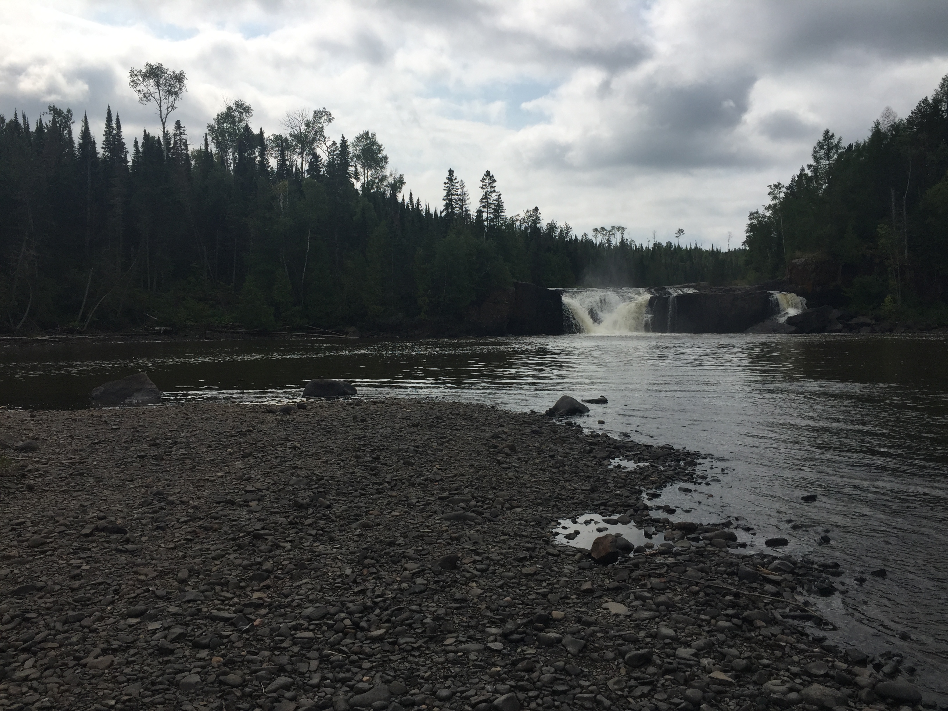
Almost a couple miles upstream from the High Falls, the Pigeon River now flows through a wider valley. This gravel bar is accessible at the end of the Middle Falls Trail in Grand Portage State Park. This is just below Middle Falls looking downstream. You are standing in Minnesota and Canada is across the river.
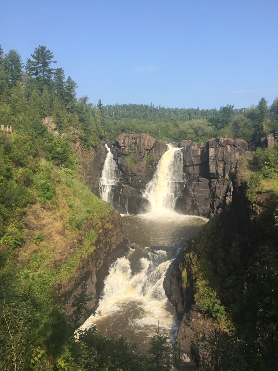
The High Falls. This is the highest waterfall in Minnesota and is located in Grand Portage State Park. This is about 1.75 miles upstream from Lake Superior.
High Falls on the Pigeon River. This shows the falls during late summer. The waterfall is nearly 120 feet high. This is the view from the U.S. side. Canada is on the opposite shore. The falls are part of Pigeon River Provincial Park in Canada.
Just downriver from the High Falls the river rushes through a gorge. The river leaves the confines of the gorge not far downstream of this point.
The Pigeon River about a quarter-mile below the High Falls just after leaving the gorge. The river flattens out beyond this point. Another half-mile downstream, the river passes under Minnesota Highway 61. From that bridge, it is one mile until the Pigeon River reaches its mouth at Lake Superior in Pigeon Bay.
Route Connections for the Pigeon River
The Pigeon River flows through several large lakes including Mountain Lake (its headwaters), Moose Lake, North Fowl Lake and South Fowl Lake. You portage between the Pigeon River and South Fowl Lake via The Fowl Portage. This portage is on the Canadian side of the river. Downstream of South Fowl Lake, the last place to leave the river is at Fort Charlotte. From Fort Charlotte you can take The Grand Portage to Lake Superior and the town of Grand Portage, Minnesota.