BIG RICE LAKE CAMPSITE: Campsite 1 (#186): Only campsite on the lake
The lake name comes from the wild rice found growing here.
This is a rather tough lake to reach and is on a lightly traveled route. If you're looking for someplace quiet, this lake may be of interest to you. This lake has decent fishing for northern pike, including some big ones.
This lake has had its water table raised by several feet from the construction of a gigantic beaver dam just downstream of where the Portage River flows out of Big Rice Lake. The increased water level has drowned thousands of trees along much of the lakes shoreline.
There is a nice campsite along the east shore of the lake, just north of the small island on the point. Almost all the trees on the small island have been drowned, so it almost looks like it was burned. The landing at the campsite is more difficult now because of the higher water.
To the north of the point where the campsite is located, in the northeast bay, is a rock that used to be popular with seagulls. It is less popular now because most of this rock is submerged. A few years ago when the water levels were down, the rock was often covered with birds.
Hook Lake drains via the Portage River into the northeast corner of Big Rice Lake. Another small feeder stream which originates at Medley Lake flows into the southwestern part of the lake.
The portage between Big Rice Lake and Hook Lake is one of the most difficult you'll come across in the Boundary Waters. There is usually a rock cairn that marks its location. This portage used to be hard to find because it was hidden in the tall grass that grew along the shoreline of the lake. Now it is difficult to find because the elevated lake level moved the start of the portage back in amongst the dead trees that now ring the lakeshore. The portage isn't used a lot, so can be brushy with frequent deadfall to work your way through.
Big Rice Lake is located in the Burntside State Forest.
References:
Beymer, Robert, Boundary Waters Canoe Area – Volume 1 – Western Region (Berkeley: Wilderness Press, 2006), 58, 62, 64, 65.
Heinselman, Miron, The Boundary Waters Wilderness Ecosystem (Minneapolis: University of Minnesota Press, 1999), 40, 41.
Pauly, Daniel, Exploring the Boundary Waters (Minneapolis: University of Minnesota Press, 2005), 83, 87, 88.
Click on the photos below to see the full resolution image - Use your browsers back button to close photo and return to this page.
PADDLING FROM THE PORTAGE RIVER TO BWCA CAMPSITE 186
Paddling from the outlet of the Portage River to the only campsite on Big Rice Lake. This campsite is located along the east shoreline on the south side of the point, just north of the offshore island.
Small island visible to the far left of your view. Looking to the southwest from Big Rice Lake's only campsite, which is located on the east side of the lake. Visit the Campsite -or- Explore Another Route ***********************************************END OF ROUTE***********************************************
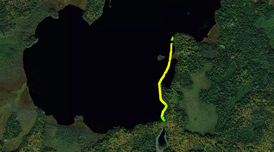
PADDLING FROM BWCA CAMPSITE 186 TO THE HOOK LAKE PORTAGE
This route takes you to the left of that island just offshore of the point just visible to the far left of the image.
Traveling south along the east shoreline between the campsite and the start of the portage to Hook Lake. The Hook Lake portage location is marked by a helpful rock cairn (don't assume that the cairn will always be here). Portage to Hook Lake -or- Explore Another Route ***********************************************END OF ROUTE***********************************************
PADDLING FROM THE HOOK LAKE PORTAGE TO THE OUTLET OF THE PORTAGE RIVER
Because the water level of Big Rice Lake has been raised several feet by the huge beaver dam near the outlet of the Portage River, you now have to navigate through this wreckage of drowned trees to get to the very muddy start of the Hook Lake portage. You can just make out the rock cairn that marks the location of this portage (just right of center in the background on the flat rock).
Beginning from the Hook Lake portage, make your way along the east shore of Big Rice Lake. Once near the lakes only campsite, head on a relatively direct route to where the Portage River flows out of the lake.