ISABELLA LAKE CAMPSITES: Campsite 1: (#1923) - On south shore just west of Entry Point 35 portage Campsite 2: (#1924) - On south shore, just east of the Entry Point 35 portage
Campsite 3: (#1922) - On south shore, just west of Campsite 1923 on point - CAMPSITE STILL CLOSED AS OF 07/25/2021
Campsite 4: (#2320) - East most campsite on south shoreline on point
Campsite 5: (#1919) - East shoreline on point just west of the lakes largest island
Campsite 6: (#1918) - East campsite on south end of lakes largest island
Campsite 7: (#1917) - West campsite on south end of lakes largest island
Campsite 8: (#1916) - On small island in northwest part of lake
Isabella Lake lies just north of the former site of Forest Center, a town that existed solely as the hub of a logging camp for the Tomahawk Timber Company. The town supported a population of around 250 people. From Forest Center an extensive network of roads was extended to the west, north and east well into what is now the Boundary Waters. Many of these old logging roads are still easily visible today on satellite images of this area. The Powwow Trail is built on the tread of these old roads. This huge area of logging extended west to Bald Eagle Lake, north to Lake Insula and east of Lake Polly. As of 1948, the Duluth, Mesabi and Iron Range Railroad had laid track to within a couple hundred yards of Isabella Lake. Extensive logging continued in the area until the early 1960's. Forest Center was a ghost town by 1964. Soon after the town shuttered, the buildings were removed (Heinselman, 1999). All that remains of Forest Center now is a sign, an open field and the current entry point parking lot for Lake Isabella (Pauly, 2005).
A couple small creeks flow into the north side of Lake Isabella. However, the majority of the water enters and leaves the lake through two major rivers. The Perent River flows into the eastern side of the lake. The Isabella River flows out the western side of the lake and makes its way all the way west to Bald Eagle Lake. These two rivers offer the only route options from this area and both of them are quite long. The Perent River presents the more rugged route of the two, with many portages.
The lake used to support nearly a dozen campsites and was often quite busy. However, the condition of many of those campsites is now in question due to the recent fire, so don't assume every red dot on your map is going to be inhabitable. One benefit of the fire is that Isabella Lake now receives far fewer visitors. Therefore finding campsites and solitude are easier. The parking lot was empty on a July weekend in 2016. There were four cars in the parking lot on a weekend in July, 2021.
Isabella Lake itself is a large open and shallow lake dominated by a large island in the lakes northern half. Wind can be an issue on this wide open lake and the lack of tree cover along the shoreline increases the effects of the wind. The fishing on Lake Isabella is mostly for northern pike and walleye. Some other species, not as commonly found in the BWCA, are also present.
References:
Beymer, Robert, Boundary Waters Canoe Area – Volume 1 – Western Region (Berkeley: Wilderness Press, 2006), 242, 245, 247.
Beymer, Robert, Boundary Waters Canoe Area – Volume 2 – Eastern Region (Berkeley: Wilderness Press, 2006), 43, 45.
Heinselman, Miron, The Boundary Waters Wilderness Ecosystem (Minneapolis: University of Minnesota Press, 1999), 56, 57, 100, 115, 116, 143, 201, 276, 277.
Pauly, Daniel, Exploring the Boundary Waters (Minneapolis: University of Minnesota Press, 2005), 200-223.
Rom, William N., M.D., Canoe Country Wilderness (Stillwater: Voyageur Press, 1987), 43.
Click on the photos below to see the full resolution image - Use your browsers back button to close photo and return to this page.
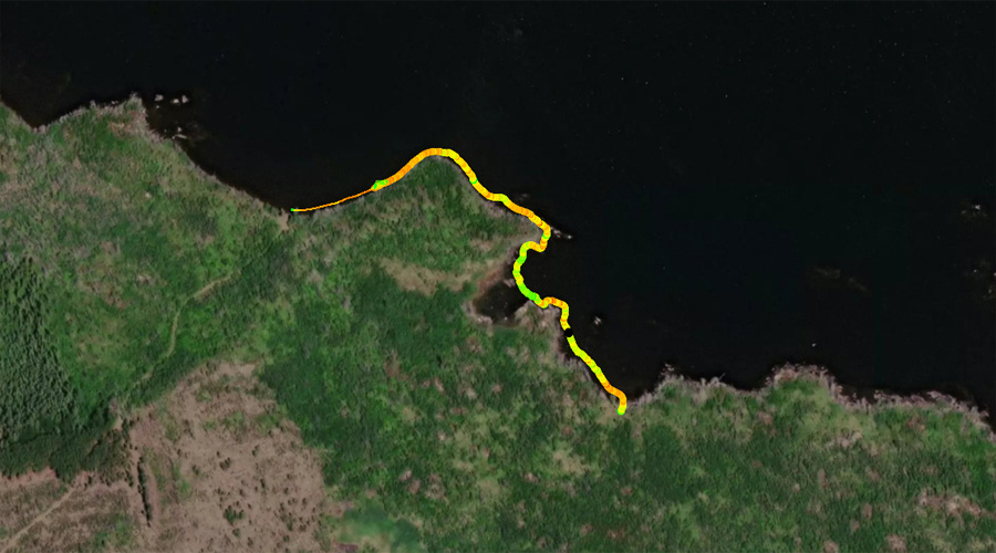
PADDLING FROM BWCA ENTRY POINT 35 TO BWCA CAMPSITE 1923
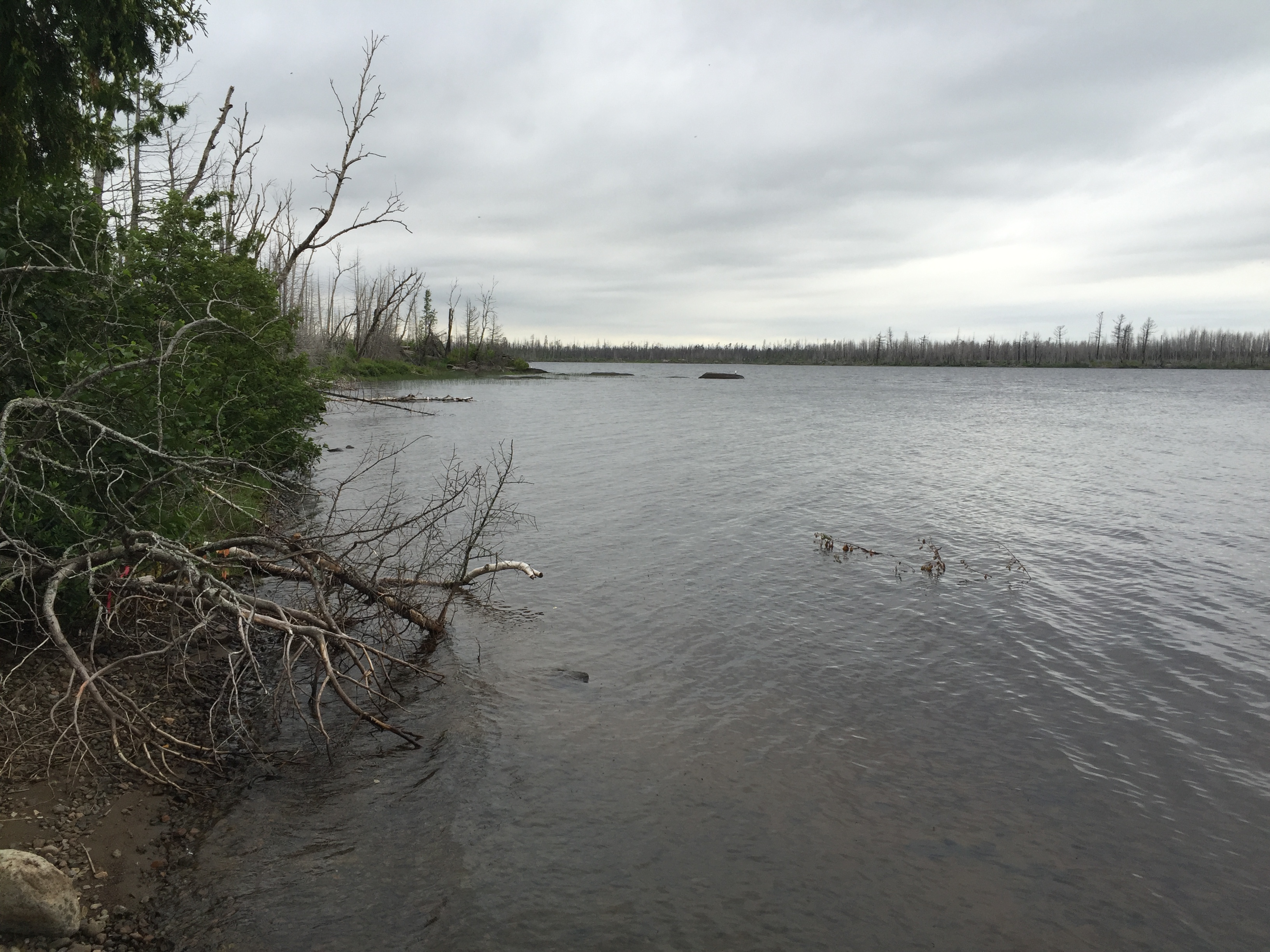
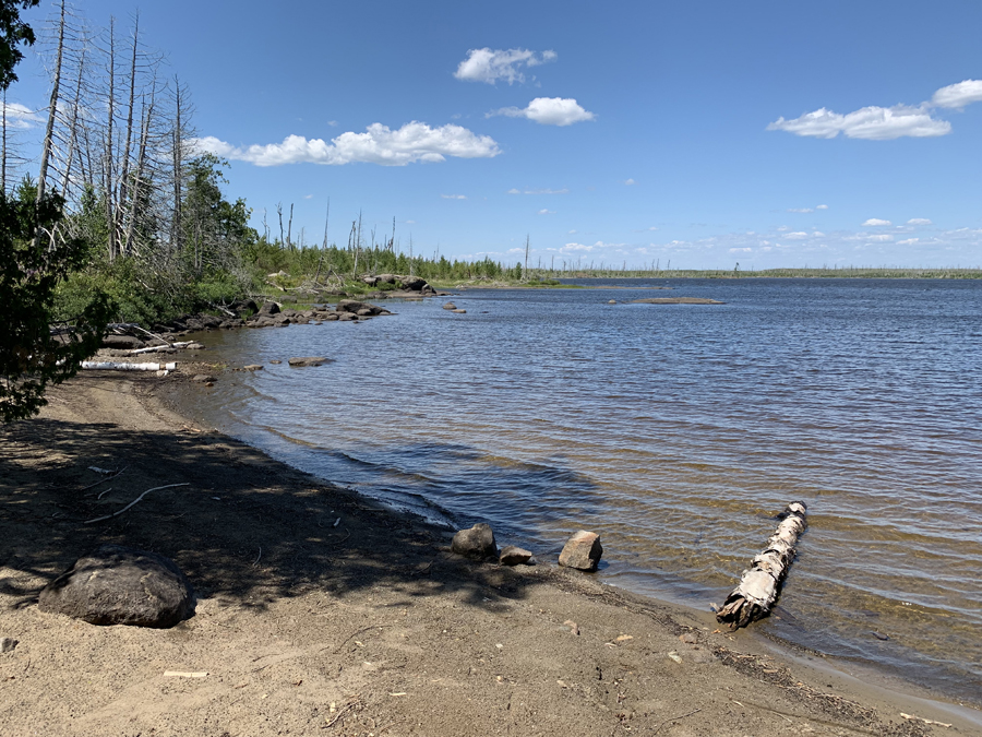
Looking to the west along Isabella Lake's south shoreline.
Similar view as above but with higher water conditions (July 2016).
Windy day paddling from the BWCA Entry Point 35 portage landing to the west along the south shoreline of Lake Isabella. This route ends at BWCA Campsite 1923 (July 2021).
Pulled up on the beach that runs along the shoreline in front of BWCA Campsite 1923 (July 2021). Visit the Campsite -or- Explore Another Route ***********************************************END OF ROUTE***********************************************
PADDLING FROM CAMPSITE 1923 TO THE ISABELLA RIVER PORTAGE
From BWCA Campsite 1923, paddle toward the west along the southern shore of Lake Isabella. It is a windy day and you are going against the wind in this direction. Once near the entrance to the Isabella River, the low water levels make it difficult to find a path through all the submerged rocks over to the portage landing on the north shore. Once reaching the portage, it is an easy 42 rod carry over to the Isabella River. You will cross the Powwow Trail about midway along this portage.
Pulled up on the beach that runs along the shoreline in front of BWCA Campsite 1923 (July 2021). Portage to the Isabella River -or- Explore Another Route ***********************************************END OF ROUTE***********************************************
PADDLING FROM THE ISABELLA RIVER PORTAGE TO THE BWCA ENTRY POINT 35 PORTAGE
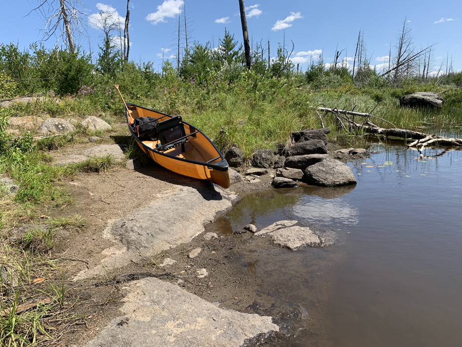
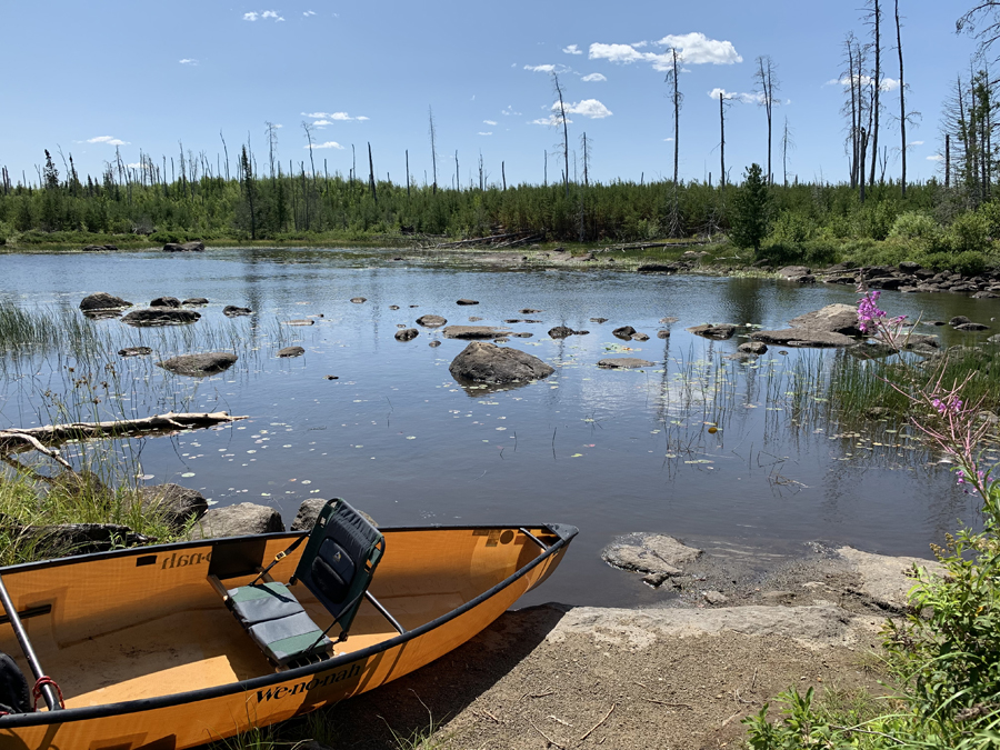
View from the Isabella River portage. This is what it looks like during drought conditions. You will most likely have to walk or line your canoe through this maze of boulders just offshore (July 2021).
Rough paddle heading back to the east across Lake Isabella. Winds approaching 30 miles per hour at your back. Little paddling is required as the wind provides most of the propulsion. Actually dragging a paddle in the water to slow momentum. Hauled the canoe over some of the points along the shoreline and used the points as windbreaks. It was too difficult to control canoe when paddling farther out into the lake.
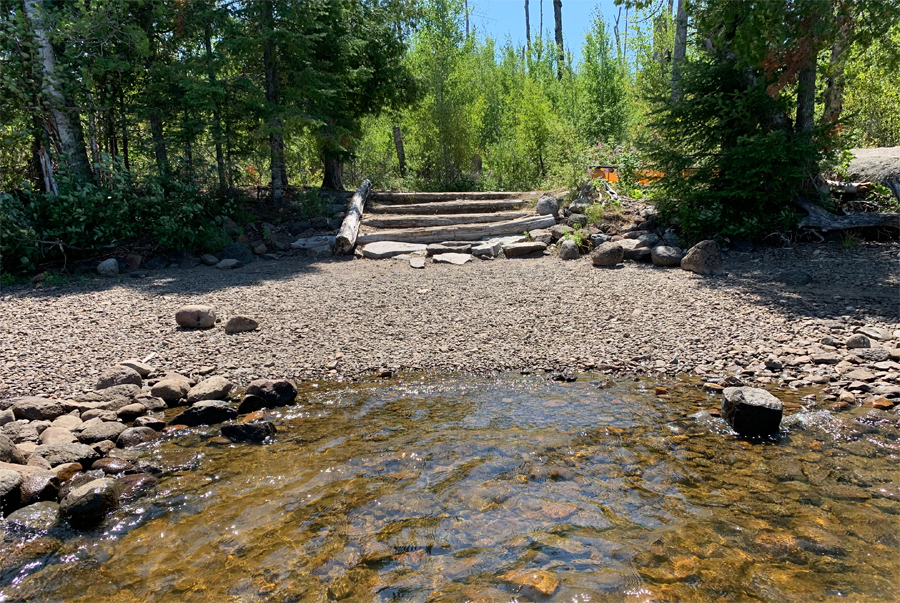
Arrival at the practically perfect landing. Up those steps is the start of the portage to the BWCA Entry Point 35 parking lot (July 2021). Portage to the BWCA Entry Point 35 parking lot -or- Explore Another Route ***********************************************END OF ROUTE***********************************************
WALKING SHORELINE OF LAKE ISABELLA FROM BWCA CAMPSITE 1924 TO THE BWCA ENTRY POINT 35 PORTAGE
Our walk starts here, on the beach in front of BWCA Campsite 1924. This campsite is nearly 1/3rd mile to the east of the BWCA Entry Point 35 portage landing. View here is to the west in our intended direction of travel (July 2021).
Because there was a drought going on at the time of this visit, the water level of Lake Isabella was way down. This exposed a lot of shoreline. Much of the shore of Lake Isabella is flat and made of small rocks and even some sand. You can walk much of the south shore of the lake. Never had to walk through water more than shin deep. The lake bottom is hard, being made of sand and small rocks. Explore Another Route ***********************************************END OF ROUTE***********************************************
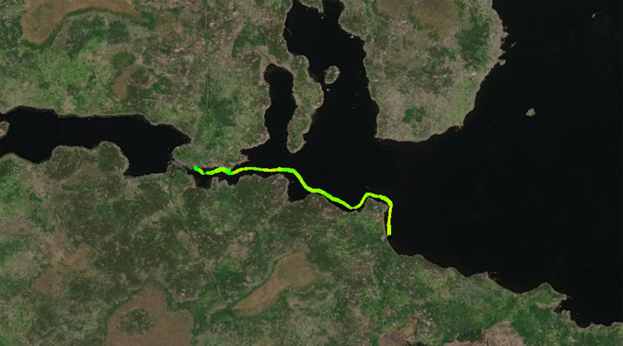
Route Connections for Lake Isabella
From Lake Isabella, you can portage into the Isabella River or the Perent River. You can also exit the wilderness by portaging from the lake to the BWCA Entry Point 35 parking lot.